
by Ben Huseman
by Ben Huseman
The purpose of The Compass Rose is to raise awareness of Special Collections' resources and to foster the use of these resources. The blog series also reports significant new programs, initiatives, and acquisitions of Special Collections.
This coming Fall -- Thursday, September 30th, Friday, October 1st, and Saturday, October 2nd, 2021 -- UTA Libraries Special Collections celebrates the donation of a major collection of antique maps of Africa along with the Twelfth Biennial Virginia Garrett Lectures on the History of Cartography and joint meetings of the International Cartographic Association’s Commission on the History of Cartography and the Texas Map Society. The lectures have the overall theme “Coordinating Cartographic Collections” and will be both in-person and virtual. The lectures will include distinguished international guest lecturers as well as members of the UTA faculty. The lectures will be accompanied by a “BLOCKBUSTER” exhibit, also both physical and virtual, “Searching for Africa: the Map Collection of Dr. Jack Franke” consisting of over 180 items (mostly original rare maps, but also original printed images and rare books) covering four centuries, from 1493 to 1900. The physical exhibit promises to be a rare treat – the largest exhibit ever mounted at UTA Libraries Sixth Floor Special Collections – covering a total of three rooms: the Virginia Garrett Map Library, the four bays of the Jenkins Garrett Library, and the “Parlor” where the lectures will be held. Visitors will find themselves literally walking into an old-fashioned “Cabinet of Curiosities.” In addition, a gallery guide will accompany the exhibit and include extensive explanatory information about how the maps were produced and for whom they were intended.
The growing Africa Map Collection of Dr. Jack Franke (UTA Distinguished Alumnus, Class of 1987) already consists of over 500 rare original maps, and it adds a whole new dimension to the UTA Libraries cartographic collections, already renowned for their breadth in the cartographic history of Texas, North America, the Gulf of Mexico, and the Caribbean. Dr. Franke’s maps offer students, researchers, faculty, and the public greater opportunities to see in person and compare a wider variety of antique maps relating to the histories of the diverse peoples that comprise the DFW area, Texas, the nation, and the world. Our local collections acquire a better global perspective with this acquisition.
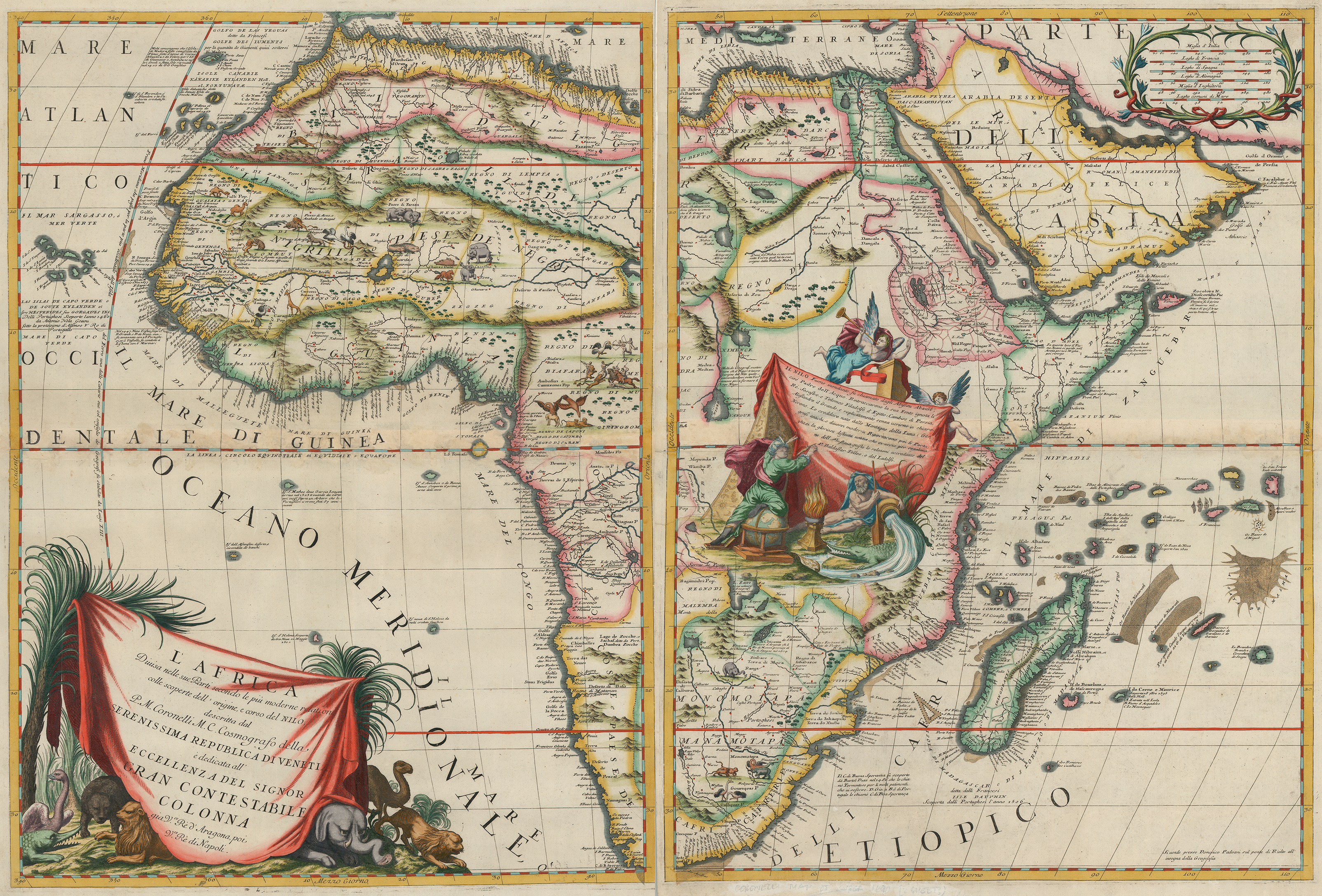
Vincenzo Maria Coronelli, L'Africa divisa nelle sue Parti..., engraving with applied color on two sheets of paper, 61 x 45 cm., from Coronelli, Atlante Veneto, vol. 1 (Venice: Domenico Padoani, 1692). UTA Libraries, Gift of Dr. Jack Franke
This large double-sheet map of Africa is the work of the Venetian cartographer, theologian, and mathematician Vincenzo Maria Coronelli (1650-1718) who gained international fame as a globe-maker for French King Louis XIV and as the author of atlases and books on globes. His Africa map and his map of North America, already in UTA's collection, are quite similar to the images of Africa and North America on his other globes and maps. Coronelli drew upon a variety of French, Portuguese, and ancient sources available to him in France and Italy just as he based his map of North America upon a variety of French and Spanish sources. The decorative title cartouche with drapery at lower left in the Africa map bears a dedication (in Italian) to a member of the Colonna family and includes African animals derived from earlier published works. Coronelli strategically placed the second cartouche over a portion of Africa's interior for which he had little information. It shows a geographer-scholar-scribe recording upon a cloth draped over an Egyptian stele various reference sources for the depiction of the Nile or “father of waters” – here personified by a reclining old man holding an oar next to an overturned vase spilling water over a crocodile.
Coronelli's large two-sheet map of Africa from his Venetian atlas joins his large two-sheet map of North America, originally from the same atlas and also at UTA..
Coronelli's famous (or infamous) map of North America shows California inaccurately as an island and the Mississippi River flowing through what became Texas.
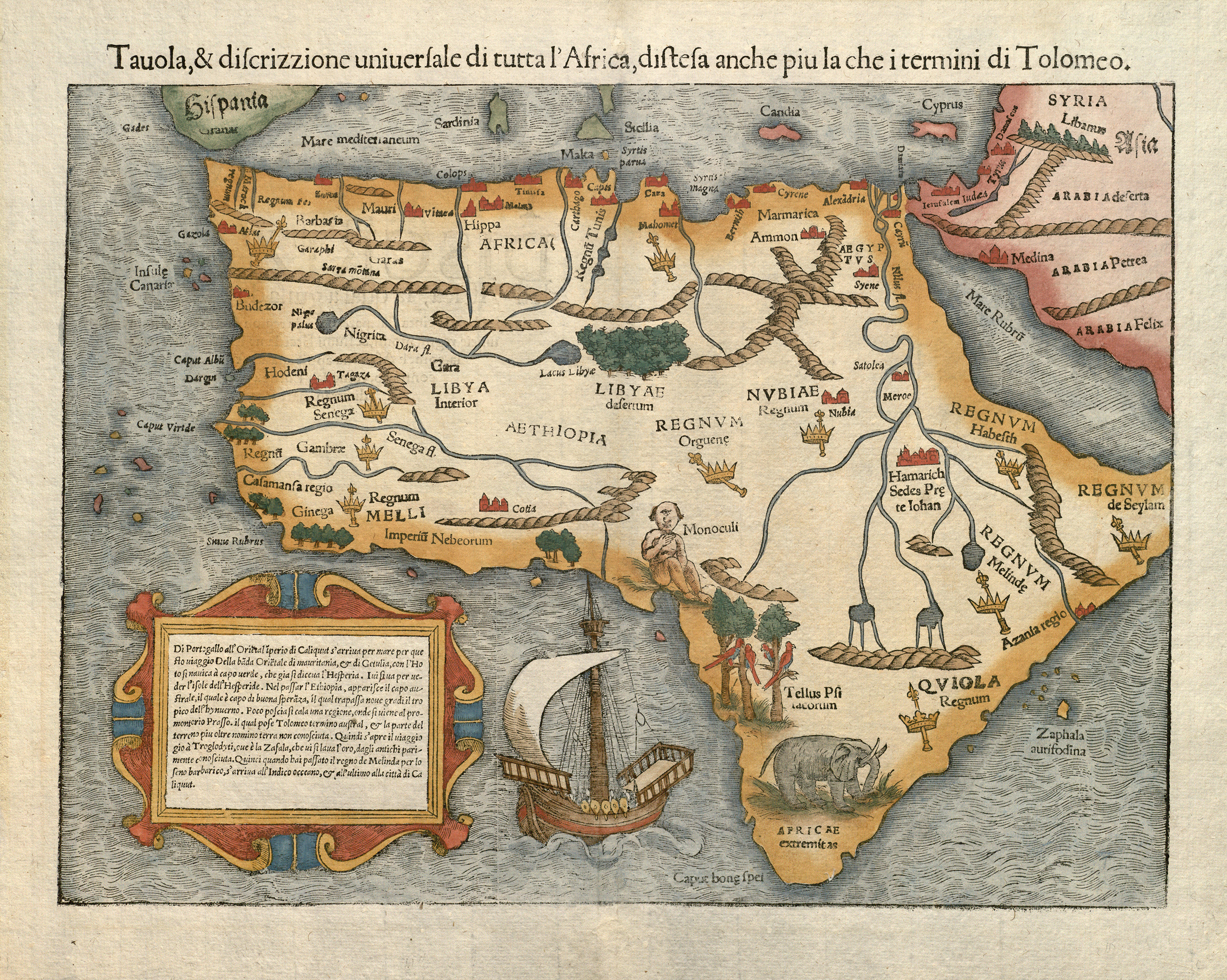
Sebastian Münster, Tavola & Discrizzione Universale di tutta l’Africa…, engraved woodcut with applied color on paper, 25.5 x 34.3 cm., 1558, from Ptolemy, Geographia. (Basel: 1558; first published in 1540). Gift of Dr. Jack Franke
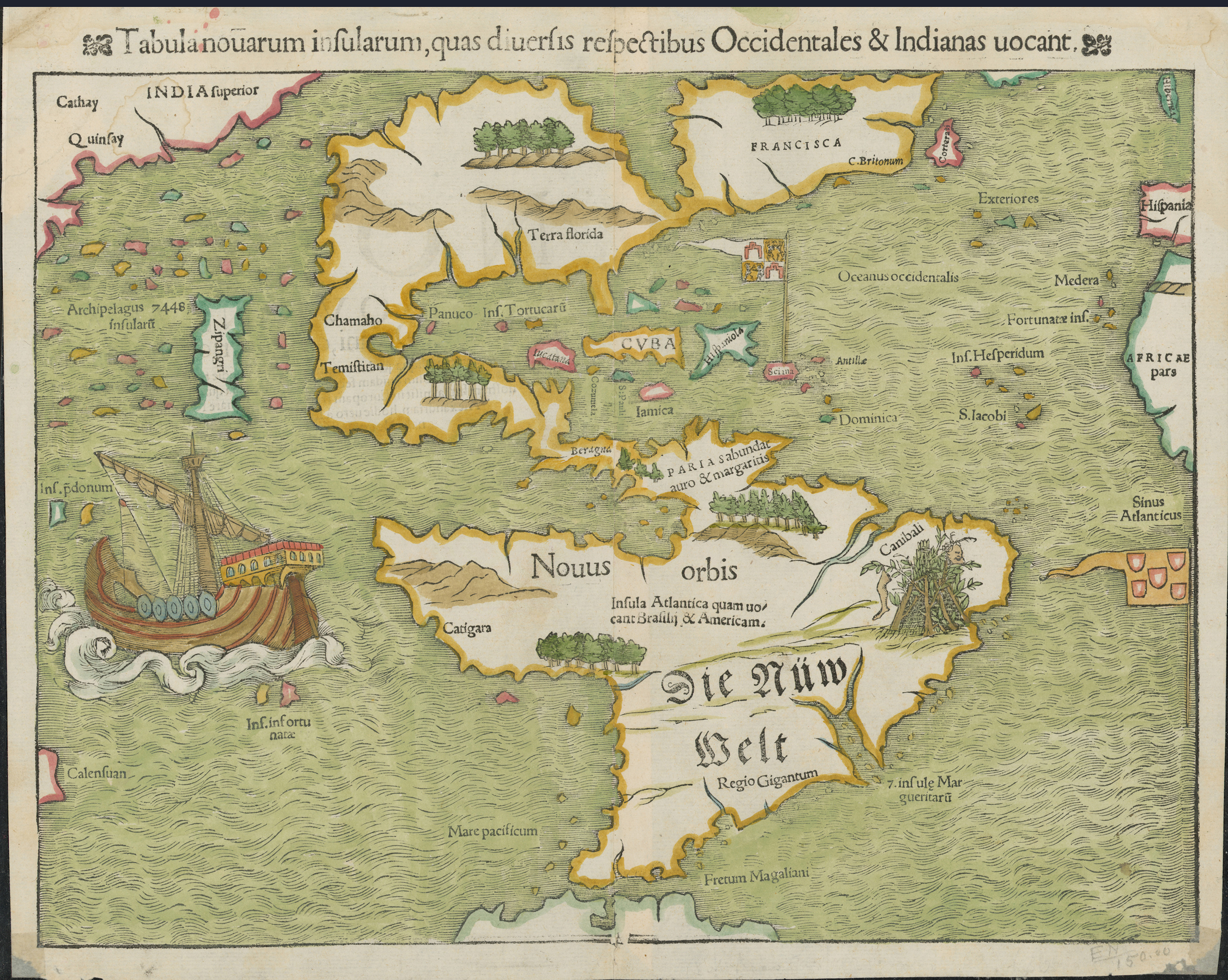
In 1540 German humanist, theologian, and scholar Sebastian Münster (1488-1552) produced “new” woodcut maps of Africa and the Americas for an updated edition of the second-century Geography by Claudius Ptolemy. Soon translated and published into several languages in addition to the original Latin, the maps were among the earliest maps to focus upon and show each of these continents in their entirety. An unusual feature of the Africa map, here seen in a 1558 Italian-language edition, was the vignette depiction of the one-eyed “Monoculi” or Cyclopes near the Bight of Benin, derived from ancient and medieval sources. In addition to an elephant and parrots in trees, Münster included cities or towns, mountains, rivers, lakes, kingdoms (denoted by royal crowns and scepters), and a medieval ship – a single-masted cog -- off the western coast of southern Africa. Near the confluence of several rivers leading from the “Mountains of the Moon” (near the source of the Nile as described by the ancient Greeks), other mountain chains, and lakes to the Nile he added “Hamarich” described as the seat of Prester John, the long sought-for mythical Christian King believed to administer a realm somewhere outside Europe. The text for the maps in Münster’s works were printed with movable metal type in various fonts and sizes attached to carved-out portions of the woodblocks used for printing the maps and images.1
Münster’s map of Africa now joins Münster’s map of the Americas, which is part of Virginia Garrett’s marvelous map collection donated to UTA Libraries’ Special Collections in 1997.
Münster's map of the Americas from a Latin edition of Ptolemy's Geographia (Basel 1552; first published 1540). UTA Libraries, Gift of Virginia Garrett
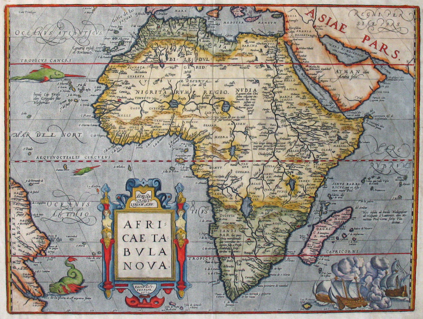
Abraham Ortelius, Africae Tabula Nova, engraving with applied color on paper, 37 x 49.5 cm., for Ortelius, Theatrum Orbis Terrarum (Antwerp: Ortelius, 1570). UTA, Gift of Dr. Jack Franke
Antwerp map dealer, collector, scholar and publisher Abraham Ortelius (1527-1598) is generally recognized as the publisher of the world’s first “true” atlas in 1570 under the title Theatrum Orbis Terrarum (Theatre of the World). Ortelius had maps by different cartographers re-engraved in a standard size and format and bound together along with a geographical text. These included this map of Africa and a map of the Americas, already at UTA. The map of Africa set a high standard for European maps of Africa, surpassing Münster’s map of Africa from 1540. It was reprinted several times from the original copper plate and included in the multiple editions of his highly successful atlas, which was issued in several languages, including Latin, Dutch, French, German, Italian, Spanish and English. The original engraver was Georg Hogenberg (1535-1590), famous as one of the creators of the successful town atlases titled Civitates Orbis Terrarum (Cities of the World),2 and the map’s influence extended well into the next century. The sea battle at lower right is a reversed copy of an image appearing on an earlier wall map of the Americas. Other decorations include two narwhals or swordfish, a sea monster, and a Mannerist-style strapwork cartouche framed by two female figures. Among the many interesting details is an inscription that describes the Niger River as flowing 60 miles underground!
With an appointment, visitors to Special Collections can now compare originals of several of Ortelius' maps of Africa and the Americas, including more detailed regional maps.
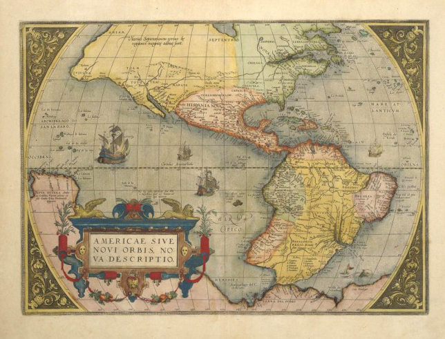
Ortelius' 1570 map of the Americas is easily recognizable by the "bulge" in South America, which he later corrected on a 1587 version, also at UTA.
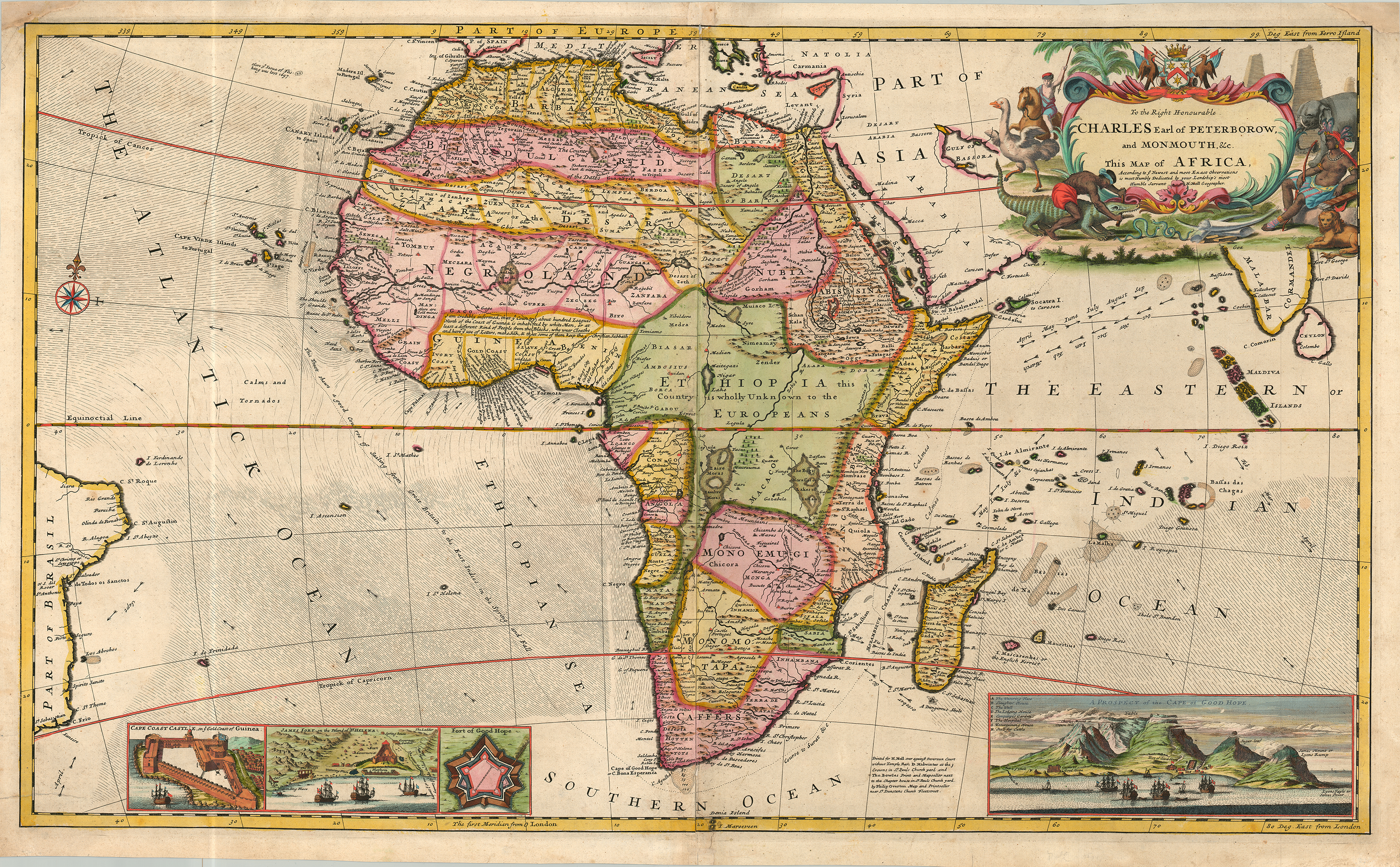
Herman Moll, To the Right Honourable Charles Earl of Peterborow, and Monmouth, &c. This Map of Africa... is Most Humbly Dedicated... Engraving with applied color on two sheets paper, joined 57.5 x 96.5 cm. (London, 1715). UTA, Gift of Dr. Jack Franke
The British geographer, mapmaker, and engraver Herman Moll (ca.1654-1732) is a long-time favorite around UTA, partly because a UTA Professor Emeritus, Dr. Dennis Reinhartz, wrote a well-regarded biography of him.3 Now, thanks to Dr. Franke’s donations, we have several originals of Moll’s maps of Africa to compare with other maps by him, found separately and in books and atlases throughout our collections. Although likely born in Bremen, Moll became a patriotic Briton after emigrating to London sometime before 1678 when he was first recorded there while working as an engraver. His engraving style is distinctive and his maps largely topographic. His great atlas folio titled The World Described…, issued in numerous editions from 1718 until 1754, usually included thirty double-sheet maps such as this one of Africa, first issued separately in 1715 by print and mapsellers and publishers Thomas Bowles and Philip Overton. In such maps Moll included many views, insets, interesting facts, and curious comments wherever there were blanks to add value and attract customers. For examples, he shows prevailing wind currents at certain times of the year for the Atlantic and the Indian Oceans along with a dotted line “for a good course of sailing from Great Britain to the East Indies in the Spring and Fall.” At the bottom of this map he included a view of “Cape Coast Castle on ye Gold Coast of Guinea,”“James Fort on the Island of St. Helena,” the British “Fort of Good Hope,” and a “Prospect of the Cape of Good Hope” at lower right showing details such as the Dutch “Castle of Good Hope,” the British “Fort of Good Hope,” Table Mountain, and other sites. A social butterfly of sorts, Moll apparently enjoyed a little “name-dropping,” particularly if it helped his map business. For example, Moll dedicated this map to Charles Mordaunt, 3rd Earl of Peterborough and 1st Earl of Monmouth (1658-1735), an influential Tory, Admiral, and participant in the War of the Spanish Succession.
Dr. Franke's gift of Moll's 1715 map of Africa fits right in with other Moll maps already here.
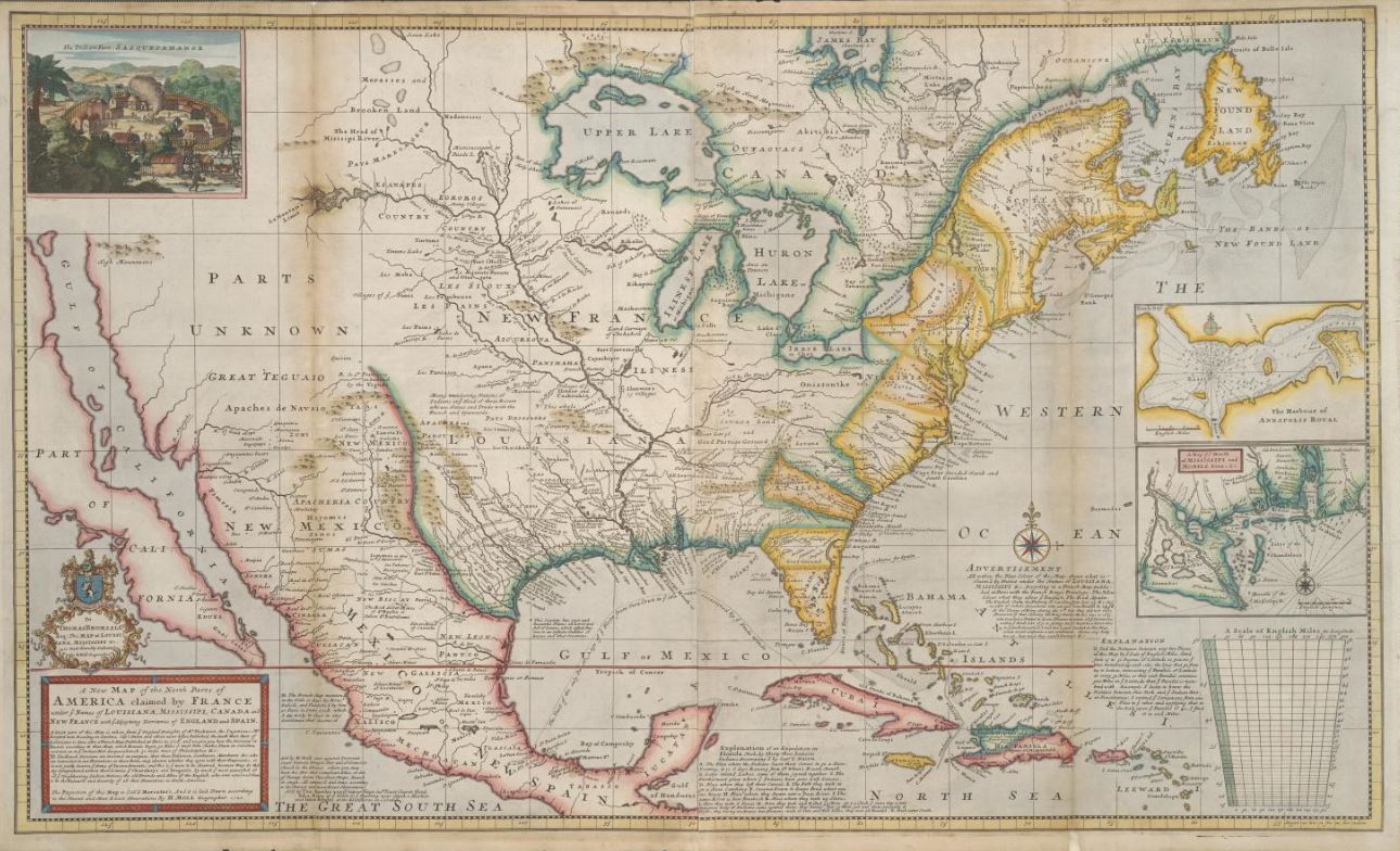
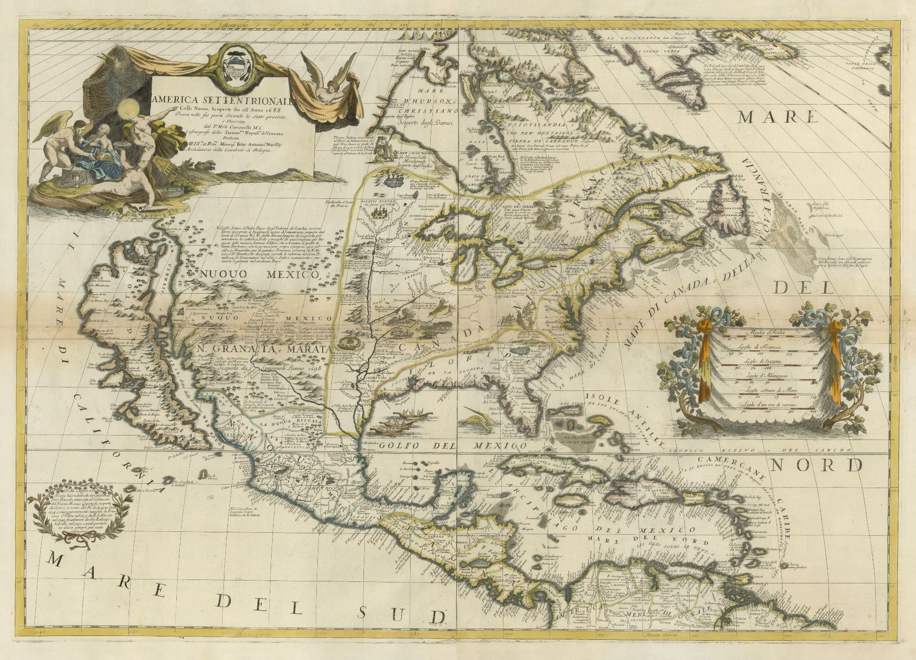
Moll, New Map of the North Parts of America... 1720. UTA Libraries Special Collections
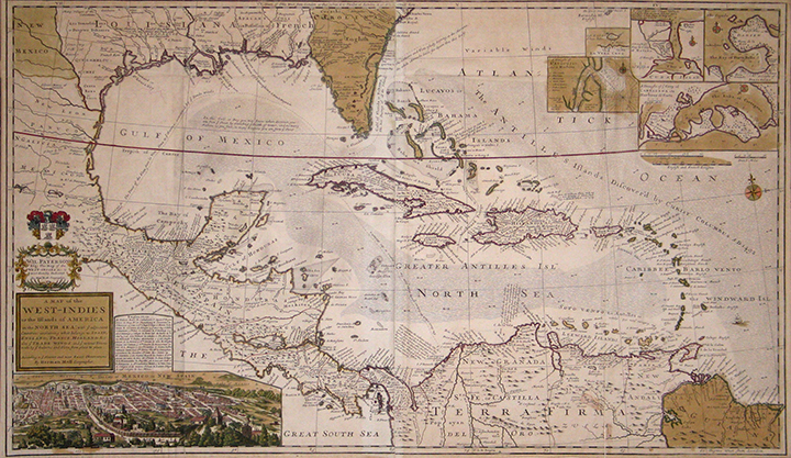
Moll's Map of the West Indies from 1715 was part of a very large and generous gift to UTA Libraries by Virginia and Jenkins Garrett back in 1997.
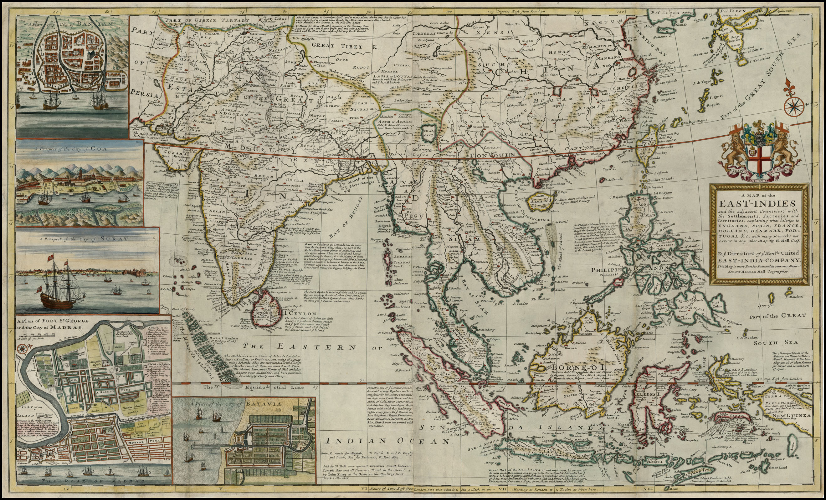
In more recent years, UTA Libraries Special Collections was able to purchase Herman Moll's Map of the East Indies from 1720 with Garrett Endowment Funds.
Comparisons afforded between Dr. Franke's African maps and existing collections at UTA Libraries Special Collections are almost limitless. They should occupy scholars, professors, students, staff, and the public for years to come.
Yet there are many items in Dr. Franke's collection for which we currently have no original New World equivalents; however, these African items directly relate to the trans-Atlantic nature of American history.
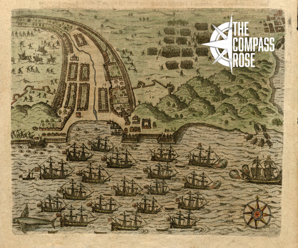
![After Battista Boazio, [Drake’s Attack on Santiago, Cape Verde Islands], engraving with applied color on paper, from Johann Ludwig Gottfried, Johann Philpp Albein and Johann Theodor De Bry, Newe Welt und Americanische Historien…(Frankfurt am Main: Merian Heirs, 1655). The University of Texas at Arlington Libraries, Gift of Dr. Jack Franke](/sites/default/files/2021-07/179_Boazio_Merian_DeBry_Drake_Cape_Verde_1655_UTA_Franke_crop_med.jpg)
After Battista Boazio, [Drake’s Attack on Santiago, Cape Verde Islands], engraving (Frankfurt am Main: Merian, 1655). UTA, Gift of Dr. Jack Franke
For example, this print conjures up similar images relating to the American side of the Atlantic. Following his successful circumnavigation of the globe from 1577-1580, English sea captain Sir Francis Drake mounted raids on Spanish settlements in the Caribbean in 1585-1586. Early in this second voyage, on November 15, 1585, his fleet attacked Santiago in the Cape Verde Islands off the coast of western Africa. This was a Portuguese colony dating to 1460, but after 1580 Portugal and its possessions had come under Spanish control through the Iberian Union under the Catholic King Philip II, arch enemy of Drake’s patron, the English Protestant Queen Elizabeth I. Drake’s men occupied the town of Santiago, pillaged, and burned it before they left on November 29. This print of Drake’s raid -- one of the first known images of the Cape Verde Islands -- is from a German abridgment of Theodor de Bry’s “Grand Voyages.” It is ultimately based upon sketches by Battista Boazio (active 1588-1606), an Italian artist, draftsman, and cartographer who worked in England compiling maps for Drake following the voyage. By the sixteenth century, the Cape Verde Islands had become a center of wealth as a result of the Portuguese slave trade. A few years before Drake’s raid, in 1562, Drake’s kinsman, Sir John Hawkins had become the first British trans-Atlantic slave trader, by taking a load of African slaves from Guinea to the Spanish West Indies, an event buried deep in our history that continues to impact events to this day.
As global events shape local history, we feel that having a globally relevant collection helps place our American, Texas, and local history collections in a better global perspective. The arrival of this new collection at UTA is an event worth celebrating! We hope to see y'all here this Fall. All Africa maps included here will be on display in Special Collections. More information will soon be available by clicking here on the Biennial Virginia Garrett Lectures.
1 For further information on some of Munster's original works at UTA see my Compass Rose blog post "City Highlights (Part Two): Munster's Cosmography."
2 For more information about Braun & Hogenberg's original city views at UTA see Compass Rose blog post "City Highlights (Part Three): Braun & Hogenberg's Cities of the World."
3 Dennis Reinhartz, The Cartographer and the Literati: Herman Moll and His Intellectual Circle (Lewiston, New York / Queenston, Ontario / Lampeter, Wales, U.K.: The Edwin Mellen Press, 1997).
Add new comment