
by Stephanie Luke
by Stephanie Luke

The purpose of The Compass Rose is to raise awareness of Special Collections' resources and to foster the use of these resources. The blog series also reports significant new programs, initiatives, and acquisitions of Special Collections.
Today Special Collections presents a special guest post from undergraduate Art History student Julia Baar. She discusses how the European vision of Egypt has been shaped by cartographers over time. This vision is deeply tied to what art historians call “The Western Canon.”
Ever heard of it? It is a concept taught to first-year art history and literature students, but rarely shared elsewhere. In literature, philosophy, and art history, the Western Canon generally means the ‘high culture’ works that have shaped thought and taste in Europe and Euro-America. The works of the Western Canon are often recognized today as the ‘classics.’ For example, the Bible has profoundly shaped what we call the Western Canon and has inspired works of art, literature, and philosophy. Other examples include Michelangelo’s Sistine Chapel, “The Odyssey,” “The Great Gatsby,” and Van Gogh’s Starry Night.
Scholars of the Western Canon have always been interested in tracing the history of societies and the lineages of ‘high culture’ over time. A ‘classic’ work that did just that was The Nuremberg Chronicle produced in 1493, a set of illustrations created from more than 1800 woodcuts (I.W. 1921). These illustrations offer a general history of the beginning of humankind to the lifetime of the then reigning German emperor, Maximilian (ibid.).
Check out two interesting illustrations in the Nuremberg Chronicle (Figs. 1 and 2) What do you see? Look closely at the top of the buildings and the shapes of the structures. Do you notice fortified brick walls, the cathedral, and the large lush tress? It looks like the vision of a medieval Germanic town we all remember from fairy tales, right? These are supposed to be two towns in Egypt. Figure 1 features Alexandria, a town at the very North end of Egypt near the mouth of the Nile River, established during the Greek occupation (Brewer 2017). Figure 2 features Memphis, an important ancient political and religious capital established around 3000 BCE and located near Cairo today (ibid.).
You might be wondering why both towns are depicted with a cathedral adorned with rooftop crosses. Egyptian religion focused on deities such as Osiris, Isis, and Horus held sway for thousands of years. Christianity became popular in the 3rd century CE, and traditional Egyptian worship was banned around the 6th century CE (Bell 1944). However, during the period this woodcut was made, Egypt was a Muslim nation. It is curious that the Nuremberg Chronicle inserts Christianity into this region when there was clear Muslim leadership. One thing is obvious: the illustrators had never been to Egypt.
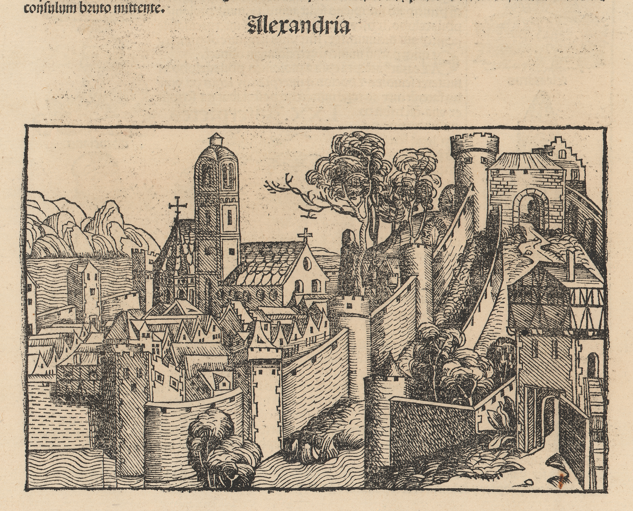
Fig. 1: Woodcut representing Alexandria, Egypt, from the Nuremberg Chronicle, 1493. UT Arlington Libraries Special Collections, Gift of Dr. Jack Franke.
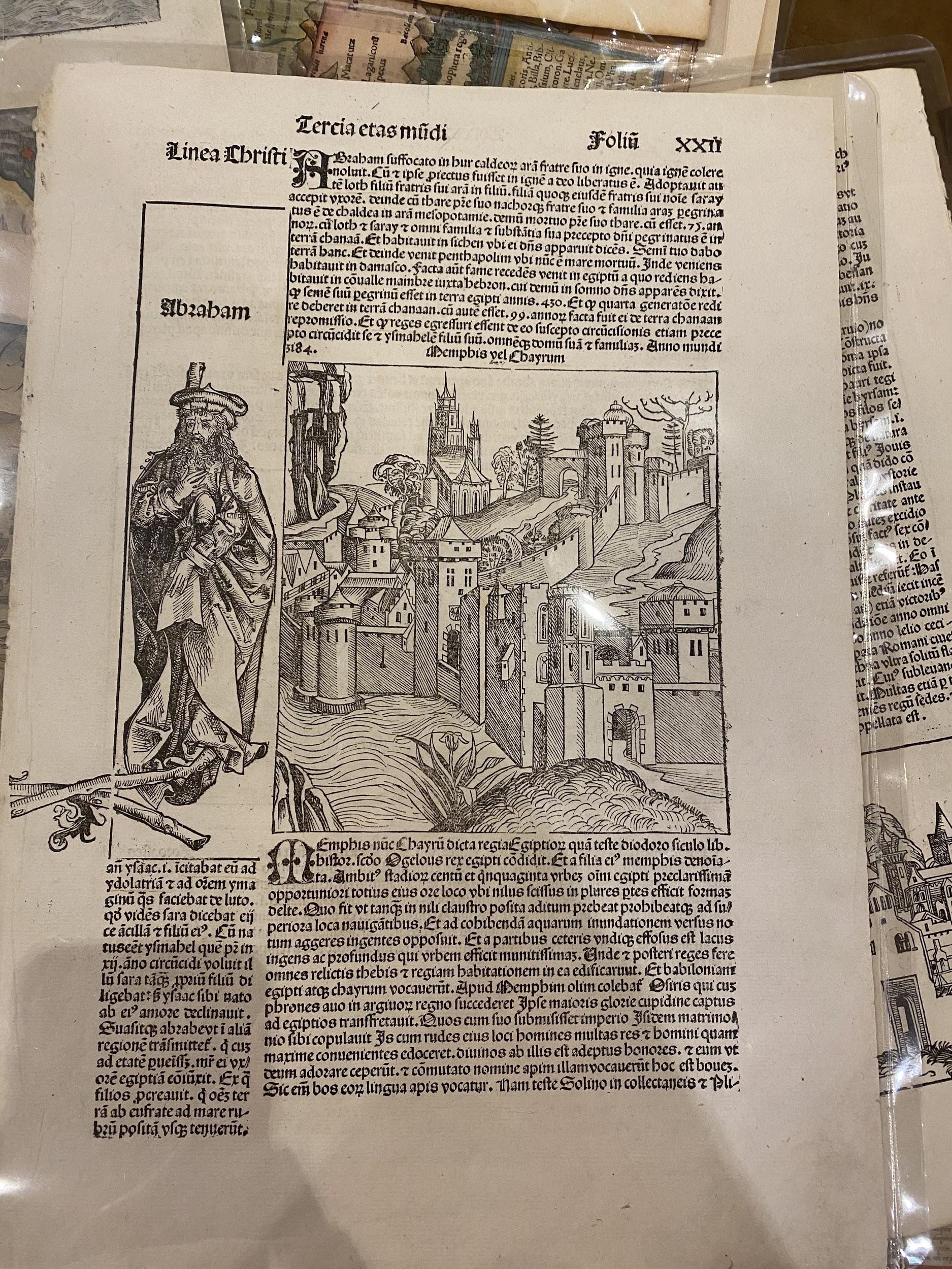
Fig. 2: Woodcut representing Memphis, Egypt, from the Nuremberg Chronicle, 1493. UT Arlington Libraries Special Collections, Gift of Dr. Jack Franke.
Let’s travel through time to 1572 to consider a depiction of Cairo (Fig 3). This map was created by a cartographer copying an original by Giovanni Domenico Zorzi (Howard 2007). This map offers far more intricate detail and a bit more accuracy than the Germanic castle towns of Alexandria and Memphis from the Nuremberg Chronicle. While the roof patterns and colors appear quite Roman or of Tuscan origin, there are no churches or crosses on top of any of the buildings. If you look closely, you will spot many blue domes, potentially indicating Islamic religious or public architecture. Although this map is far closer to the real topography of the land, there is no concrete evidence (as of the 2007 article by Howard) that has placed either Zorzi or the unknown cartographer of this copy in Cairo.
Did you notice the pyramids on the right side of the map? They don’t quite resemble the photos we all know of the Giza pyramids (which are indeed located very close to Cairo). While their presence is a step towards accuracy, there are quite a few inaccuracies that point out that this artist must have not seen these monuments in person. Each set of pyramids, grouped in twos and threes, sit upon a tall plateau, illustrated like tree stumps. These pyramids are elongated, too numerous (there are only three major pyramids at Giza), and near the bottom of the section of pyramids, the Great Sphinx is depicted in blue (quite distinct from the desert stone from which the sphinx is carved). To depict scale, the illustration includes two tiny figures with their arms stretched out, reaching up halfway to the body of the human-headed cat. Unfortunately, this attempt at scale does not do justice to the actual size of this cat.
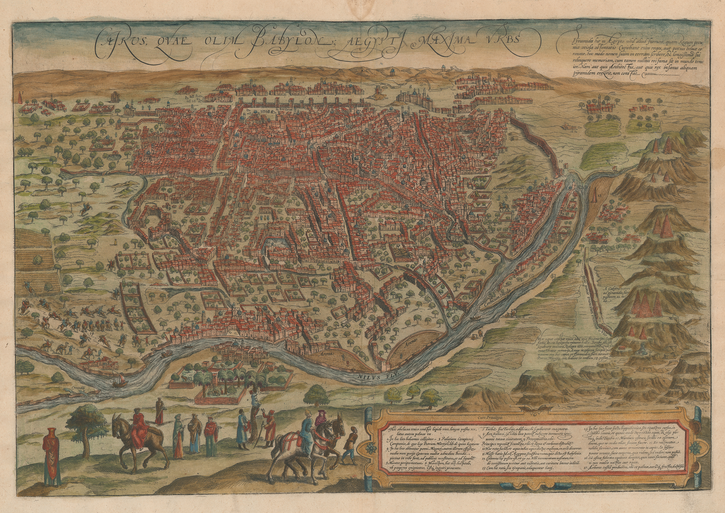
Fig. 3: After Domenico Zorzi, Cairos, quae olim Babylon, Aegypt Maxima Urbs, etching with applied color on paper, from Civitates Orbis Terrarum (Cologne: Braun & Hogenberg, 1572). UTA Libraries Special Collections, Gift of Dr. Jack Franke.
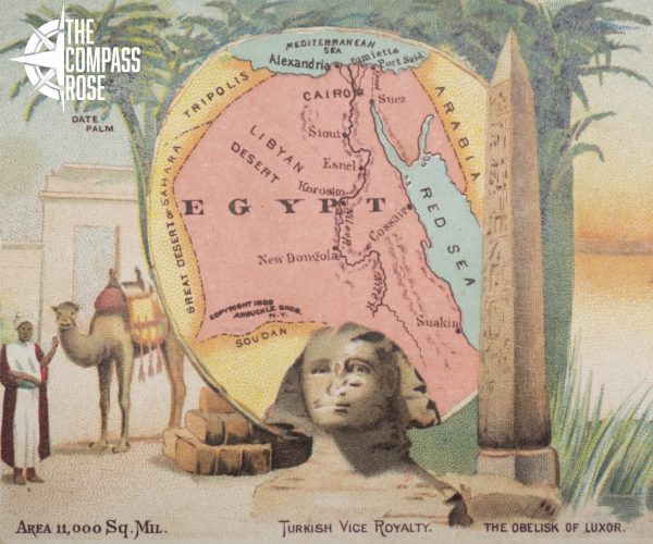
More recently, maps of Egypt became imagery in marketing campaigns, such as Figure 4 for the Arbuckle Brothers Coffee Company in 1889. Arbuckle customers were encouraged to learn a little bit about the world, through informational cards like this one, focused on geographical and even zoological facts. When someone bought a 100-pound case of Arbuckle Brothers Coffee, they received 100 cards. What a deal! In addition to commercial interests, this effort was approved by teachers and recommended for classroom use. While the overall point of these cards was to sell more coffee, the effort of educating Americans about different countries like Egypt, Russia, Spain, and Cuba, among others, contributed to public knowledge about Egypt.
The Arbuckle Brothers Coffee Company card featuring Egypt offers more accuracy than the Nuremberg Chronicles or copy of Domenicio Zorzi’s map, displaying some famous components of Egyptian history. Can you spot them? Notice the boat on the still water with the pyramids (accurately proportioned) in the background. Notice the obelisk and the sphinx centered in the foreground. Notice the entranceway with Egyptian cornice behind the camel in the left-center.
The depiction of the “Obelisk of Luxor” is interesting. Today, there are two remaining obelisks from Luxor that survive. One is in Paris, France, and the other remains in situ (in its original place). Which obelisk is this one? Do you think it’s drawn after the one in Paris or Luxor?
Another symbolic image very common in Egypt since the earliest periods is that of water, especially from the Nile. From paintings to carvings to maps, water has been depicted as one of the most praised natural features that Egypt has to offer. This is because Egyptians live in a vast desert, where their main supply of water comes from this single source, as prominently shown on the map embedded in the Arbuckle Brothers card.
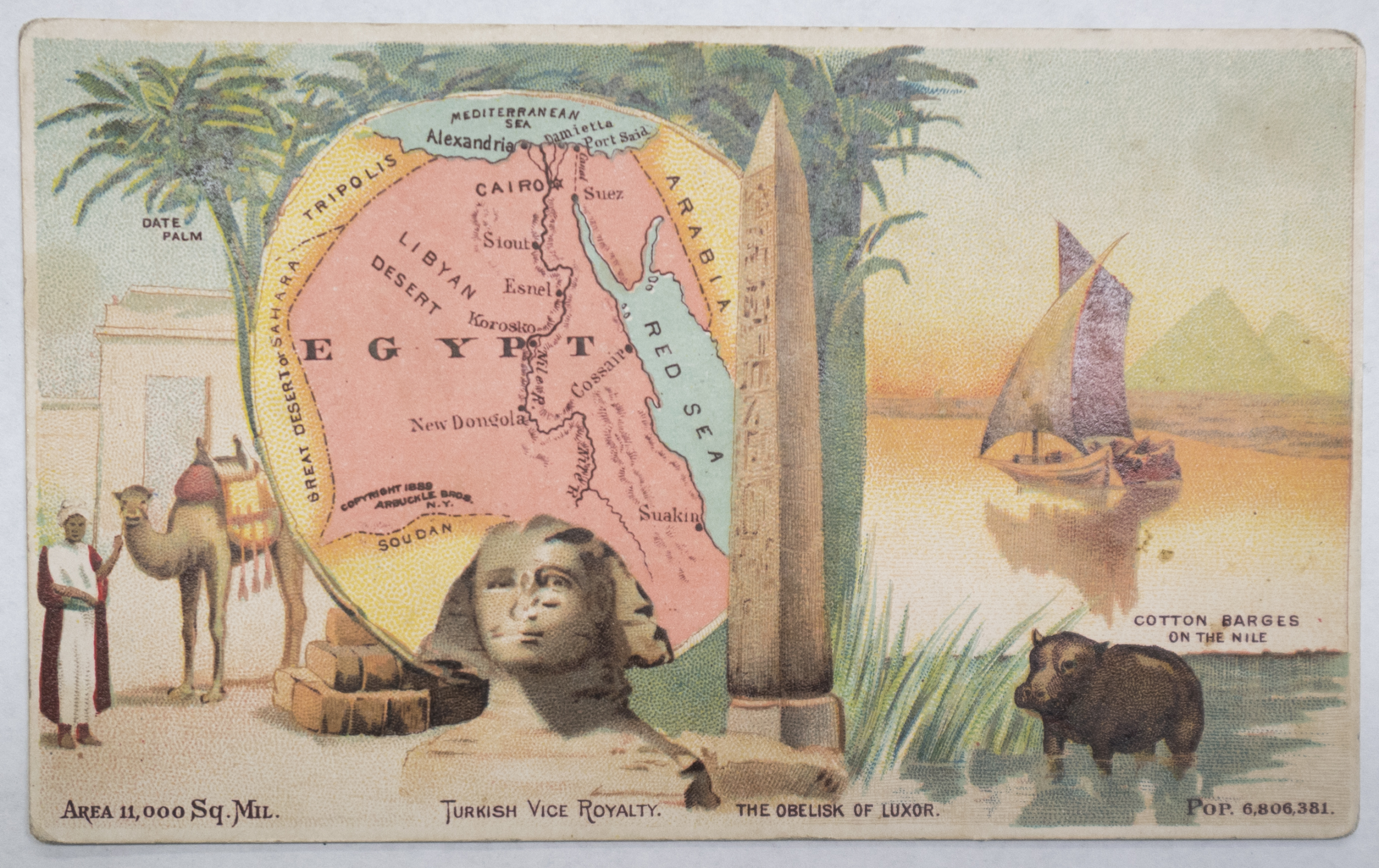
Fig. 4. Egypt, (Arbuckle Brothers Coffee Company, 1889). UTA Libraries Special Collections, Gift of Dr. Jack Franke
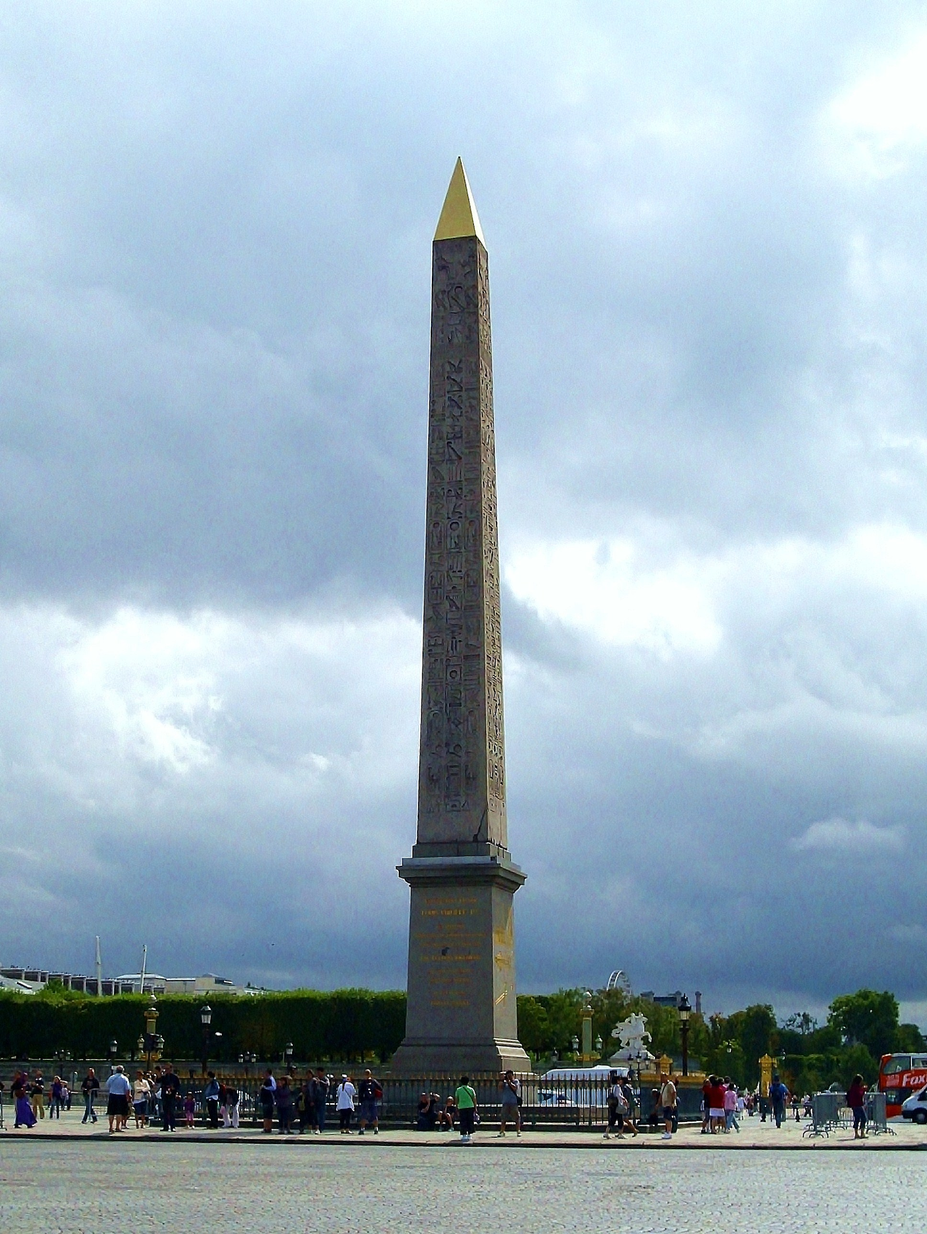
Fig. 5, New Kingdom (Dynasty 19) Maker(s), Luxor Obelisk, c. 1300 BCE, moved in 1833 from Luxor Temple to the Place de la Concorde, Paris. Wikipedia Commons.
The main problem with the Western Canon is bias. Generally, European derived ideas and arts are perceived as universal and better than other traditions. When there is a lack of knowledge, (such as when an illustrator or cartographer has never been to the place they are depicting) widely inaccurate creations can lead to new histories that undermine the real thing. The Germanic fantasies of Alexandria and Memphis or the numerous slender pyramids of Cairo influenced perceptions in Europe for hundreds of years. Cairos, quae olim Babylon, Aegypt Maxima Urbs (Fig. 3) was a popular map that was reprinted and shown all over Europe (Ben Huseman pers. comm. 2021). It was not changed to become more precise for a long time, and many people believed that those depictions reflected how the pyramids actually looked. This vision not only exaggerated the number of pyramids but understated their monumentality, spreading a false and potentially negative perception about the Egyptians and the great feats they had accomplished so early in history. The coffee company card offers a more accurate map, while exoticizing Egypt for the masses.
These four examples from Special Collections allow us to examine and even challenge the assumptions of the Western Canon. By becoming aware of the bias, we can learn more about Egypt on its own terms.
Bell, H. I. "Evidences of Christianity in Egypt during the Roman Period." The Harvard Theological Review 37, no. 3 (1944): 185-208. Accessed April 5, 2021. http://www.jstor.org/stable/1508210.
Brewer, Douglas J. Ancient Egypt: Foundations of a Civilization. Harlow, United Kingdom: Pearson, 2017.
Howard, Deborah. “Review of The True Description of Cairo, A Sixteenth-Century Venetian View,” The International History Review 29, no. 2 (2007): 355-58. Accessed April 2, 2021. http://www.jstor.org/stable/40110793.
I. W. "NUREMBERG CHRONICLE ACQUIRED." Bulletin of the Detroit Institute of Arts of the City of Detroit 3, no. 1 (1921): 10. Accessed April 3, 2021. http://www.jstor.org/stable/41500144.
Guadalupi, Gianni. The Discovery of the Nile. Cairo: American University in Cairo Press, 1997.
Comments
Wonderful work!
Excellent job, Baar! Very proud of your research and discussion here!
In reply to Wonderful work! by Leah McCurdy
Re: Wonderful work!
Dr. McCurdy,
Thank you for reading and sharing this feedback! We appreciate your support. : )
Alexandra Pirkle
Editorial Services Coordinator
Wonderful work by Julia Baar
I am delighted by the quality of this work and I applaud the excellent work of a variety of archival sources in Special Collections. Congratulations!
In reply to Wonderful work by Julia Baar by Beth Wright
Re: Wonderful work by Julia Baar
Dr. Wright,
Thank you for reading and commenting! We appreciate your support.
Alexandra Pirkle
Editorial Services Coordinator
Kudos!
Ms. Baar,
Great job on your blog of Egypt! I look forward to future blogs and articles.
Respectfully,
jf
In reply to Kudos! by Jack Franke
Re: Kudos!
Dr. Franke,
Thank you for reading and leaving a comment! We appreciate your support.
Alexandra Pirkle
Editorial Services Coordinator
Bravo!
Bravo!
Add new comment