
by Ben Huseman
by Ben Huseman
The purpose of The Compass Rose is to raise awareness of Special Collections' resources and to foster the use of these resources. The blog series also reports significant new programs, initiatives, and acquisitions of Special Collections.
Note: This is Part Three of a series of Compass Rose posts on Special Collections' city views. Click here for City Highlights (Part One): African Cities from the Nuremberg Chronicle or Click here for City Highlights (Part Two): Munster's Cosmography.
The University of Texas at Arlington Libraries Special Collections recently acquired rare, original examples from one of the most monumental and popular “virtual reality” books of the sixteenth century: Georg Braun and Frans Hogenberg’s Civitates Orbis Terrarum or “Cities of the World,” published in six Books in Cologne from 1572-1617. For many years Special Collections has owned a three-volume reprint set published in 19661, but the experience of viewing these just does not compare with the thrill of seeing the original hand-colored etchings on handmade paper. Now, thanks to another generous donation by Dr. Jack Franke (Distinguished UTA alumnus, class of 1987) as well as purchases with the Virginia Garrett Cartographic Endowment Fund, we can also show students, faculty, and visitors some of the 16th-century originals.
Georg Braun (1541-1622) was a Catholic cleric from Cologne who was the main editor and administrator of the project. He wrote most of the text. His partner, Frans Hogenberg (1535-1590) was an engraver from the Flemish town of Mechelen (Malines) near Antwerp. In addition to being the chief engraver for the Civitates project, Hogenberg also engraved many of the maps for what is often considered the world’s first “true” atlas of maps: Abraham Ortelius’ Theatrum Orbis Terrarum or Theatre of the World, first published in Antwerp by Christoph Plantin in 1570.2
Hogenberg, apparently a Protestant, fled Antwerp during the Dutch revolt, probably after 1565.3 Up to that time the city was the most important and prosperous Dutch city and a center for the book, print, and map trade. Spanish troops occupied Antwerp in the 1560s and sacked it in 1576, causing widespread destruction and the deaths of an estimated 6,000 of its citizens. In 1579 the city joined the Union of Utrecht and became the capital of the Seventeen Provinces. For over a year between 1584 and 1585 Antwerp was under siege. In these troubled times, many merchants, intellectuals, printers, and artisans like Hogenberg left, and other places like Cologne and Amsterdam assumed greater importance in the map, print, and book trade.4
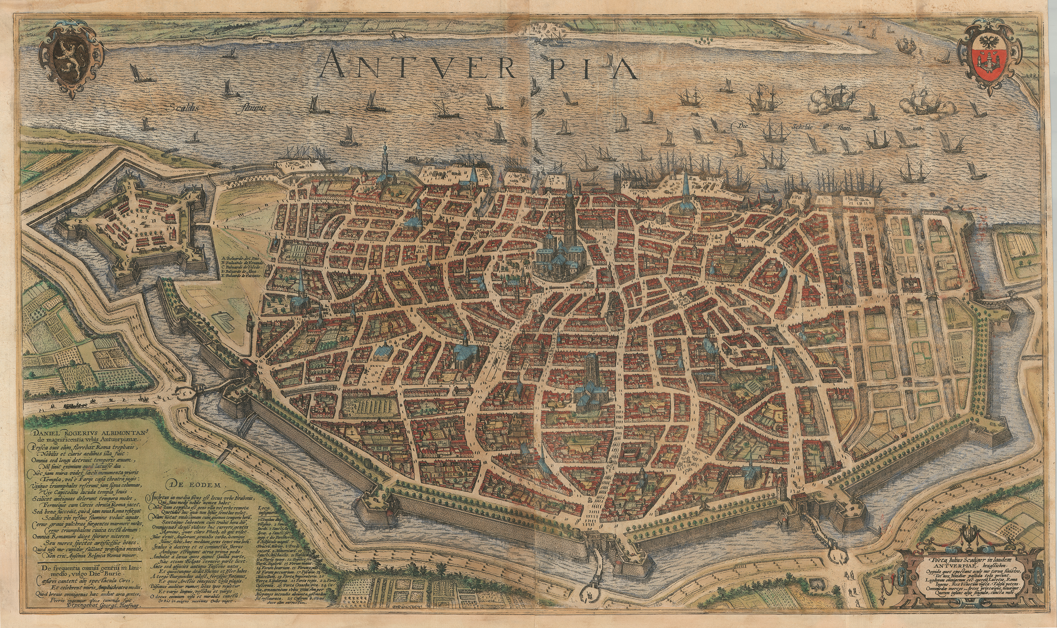
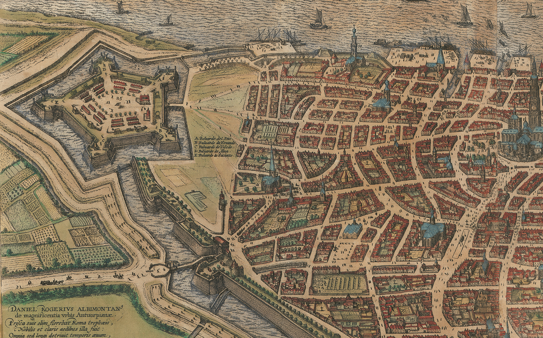
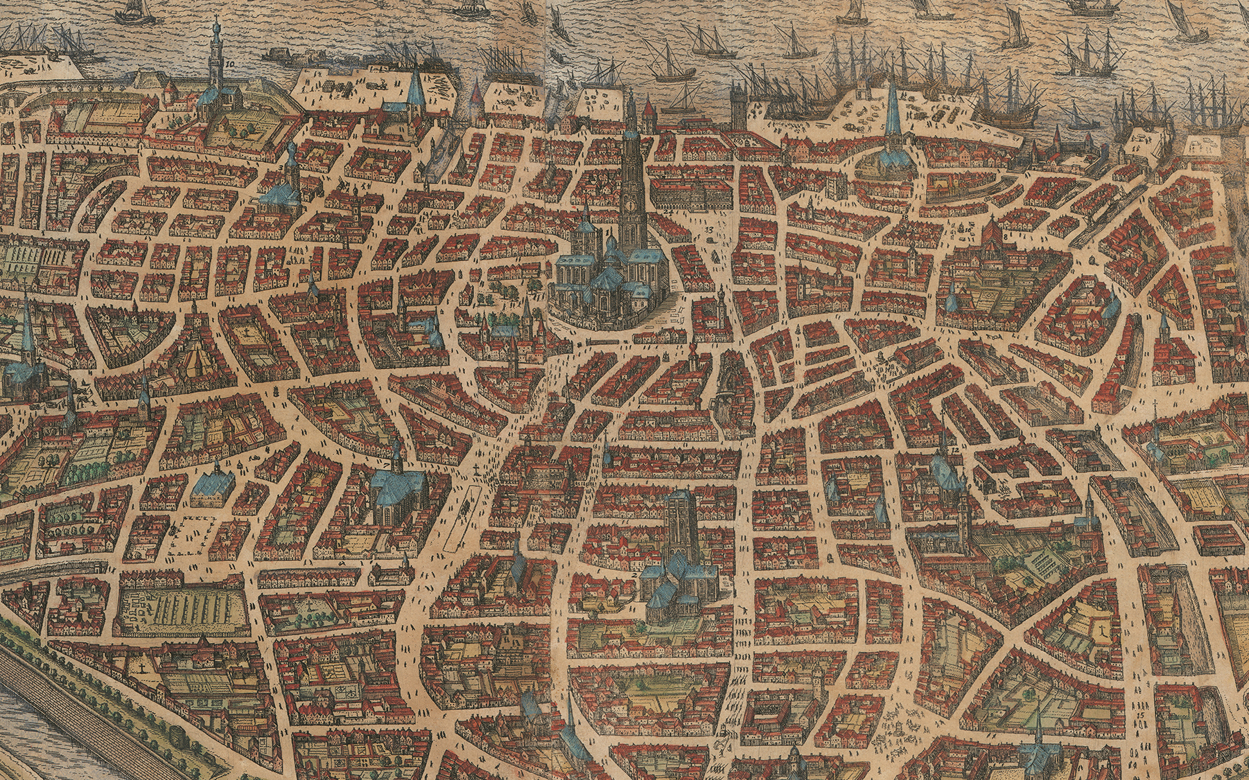
A view of Antwerp published by Braun & Hogenberg in Book I of Civitates in 1572 together with a second view of the same city they published in book V in 1598 affords not only a spectacular idea of the city’s strategic position but also partially illustrates the working method of the two publishers. The first view, taken from south-southwest, looking north-northeast, shows the city's position along the Scheldt River, its principal buildings, and its vast fortifications. Oversized figures in the foreground model local costumes of the period and the dedication praises the city's benefactors and rulers, including some of Philip II's Spanish administrators. Several historians agree that this is most likely the work of one of Braun & Hogenberg's principal and most prolific artists: Joris (George or Georg) Hoefnagel (1542-1600). The son of an Antwerp diamond merchant, the younger Hoefnagel had traveled to southern France and Spain from 1561-1567 and to England in 1568-1569, sketching cities along the way. He was back in Antwerp between these trips and during the years 1570-1577, in time to create this view and witness the ruin of his father's business when Spanish troops sacked the city in 1576. Afterwards, the young Hoefnagel left and traveled to Italy in company with the older and by then famous atlas publisher Abraham Ortelius. Along the way Joris sketched cities in Bavaria and Italy. From 1590-1600 he worked in Prague and Vienna.5
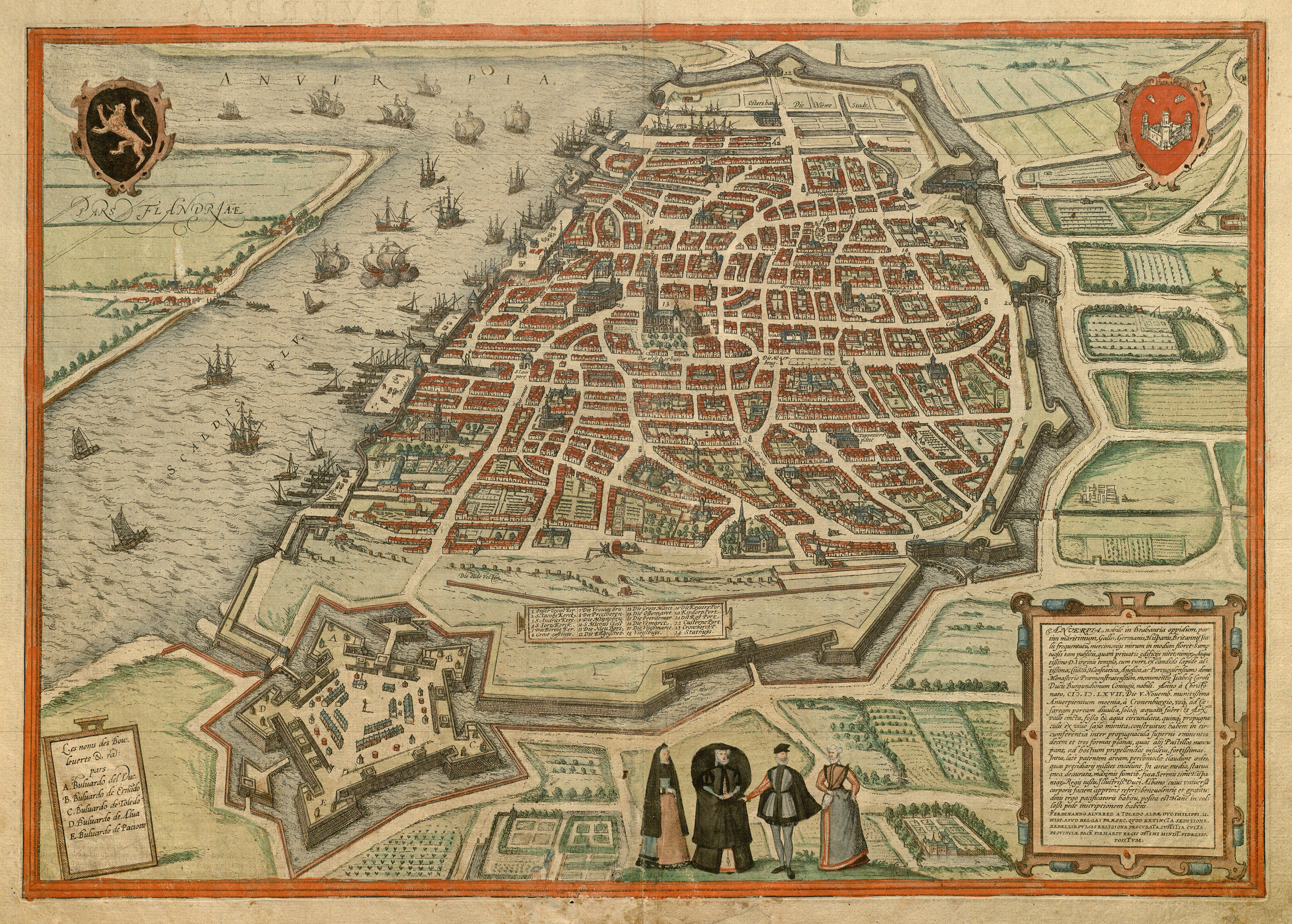
Georg Braun & Frans Hogenberg, Antwerpia, etching with applied color on paper, from Civitates Orbis Terrarum, book I (Cologne, 1572). UTA Libraries Special Collections
Detail of Braun & Hogenberg's 1572 view of Antwerp showing foreground with fortress and over-sized figures in local costumes
Detail of Braun & Hogenberg's 1572 view of Antwerp showing docks along the Scheldt, the Grote Markt (main market square #13) with the Stathuys (city hall, #24) and the Vrouwen Kerck (Church of Our Lady, #1).
The second view of Antwerp, a double-page etching and one of Braun & Hogenberg's best, was taken from the east-southeast looking west-northwest, and is credited in an inscription at the lower left to Hoefnagel. Nonetheless, Hoefnagel's view closely corresponds to a woodcut view of Antwerp attributed to Pauwels van Overbeke appearing in a book by Lodovico Guicciardini (1521-1589), a Florentine writer and merchant working in Antwerp, titled Descrittione … di tutti i Paesi Bassi ... [Description...of the entire Low Countries ...] (Antwerp, 1567). Both views resemble a view of the city by Flemish painter and etcher Hieronymus Cock (1518-1570).6 Whatever their varied sources and whomever their original creators, Braun & Hogenberg's city views, like those in Sebastian Munster's Cosmographei, drew from a variety of city view types. There were profiles (drawn as if seen from a viewpoint on the ground or just above), bird's-eye views (seen obliquely from a higher elevation), plans (drawn from directly above), or a combination of these techniques. The Antwerp views are a combination of these techniques, or as Braun explained in the foreword to Book II, "drawn in such a manner that the viewer can look into all the roads and streets and see also the buildings and open spaces."7
After Joris (Georg) Hoefnagel, Anterpia, etching with applied color on paper, from Civitates Orbis Terrarum, book V (Cologne: Gottfried von Kempen, 1598). UTA Libraries Special Collections
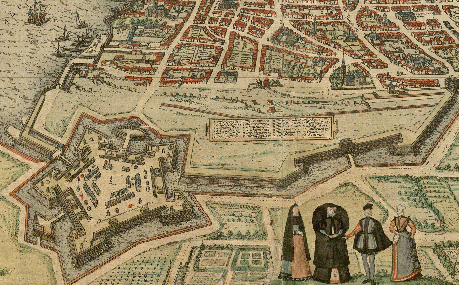
Detail of Hoefnagel's view of Antwerp showing fortress and city's south side.
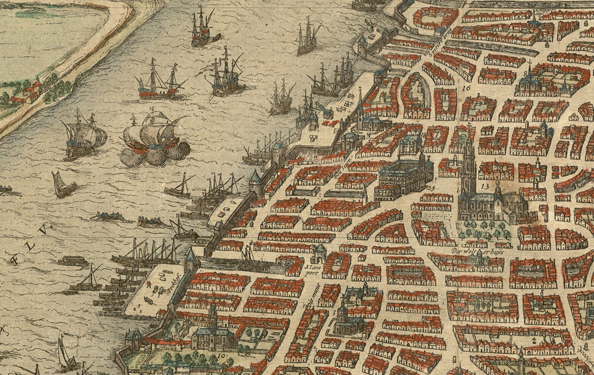
Central detail of Hoefnagel's view of Antwerp published by Braun & Hogenberg in 1598.
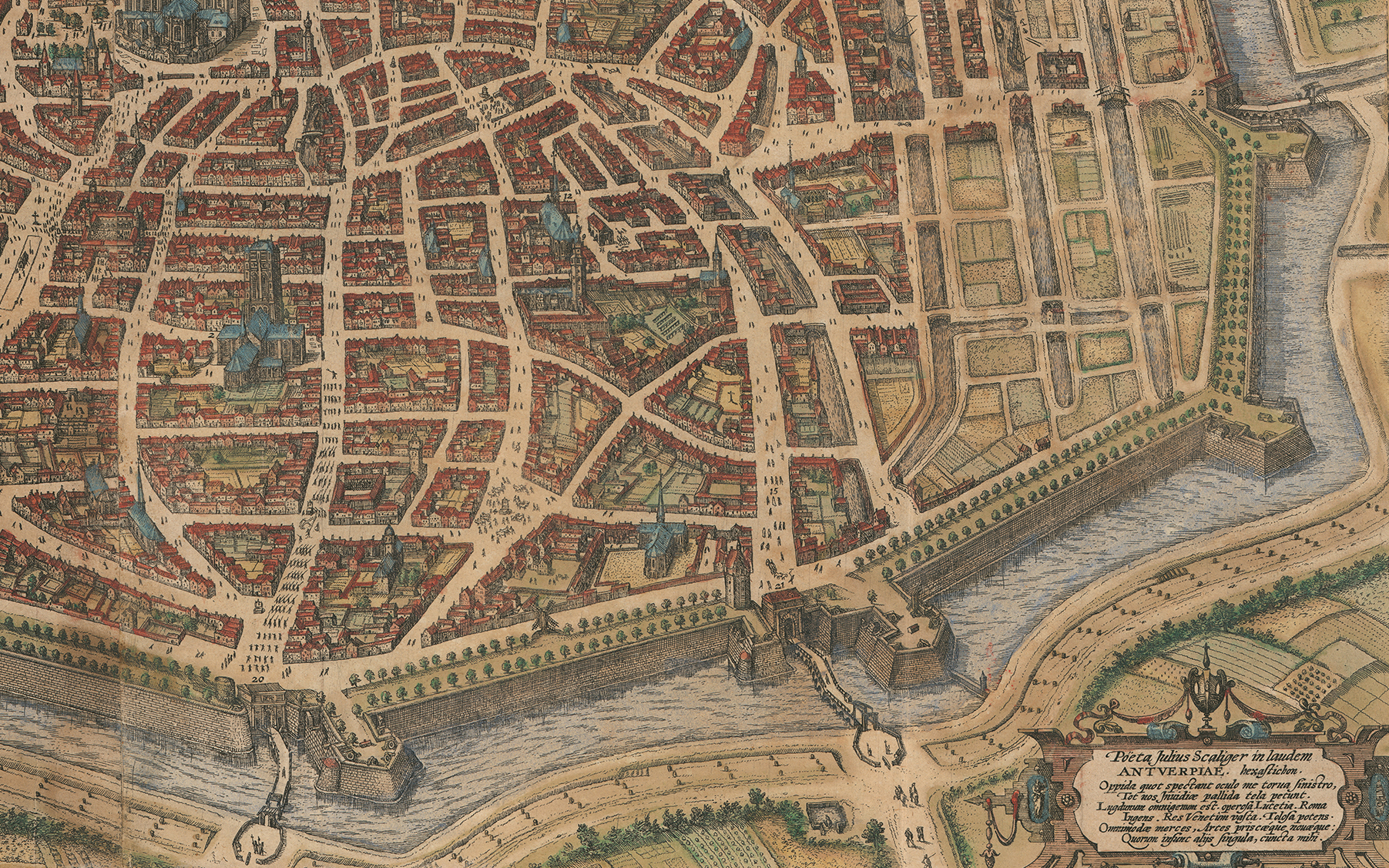
Detail of Hoefnagel's view of Antwerp published by Braun & Hogenberg in 1598 showing city's east side. Note trees growing on city walls - apparently a sign of revival that Hoefnagel may have wanted to emphasize.
While Braun & Hogenberg's project had a decidedly European bias, they nonetheless attempted to include views of cities in other parts of the world. Of 546 views, plans, or prospects, 18 relate to Africa, 5 to Asia, and 2 to America. As might be expected, accurate views from distant parts of the world were much rarer in Europe and hard to procure in the 16th century. The publishers purchased what prints and illustrated books they could and exchanged correspondence with people known to have traveled to these distant lands.8 Thanks to Dr. Franke, the African views can now be seen now at Special Collections.
This sheet from Book I, first published in 1572, depicts the cities of Aden (in present-day Yemen), Mombasa (in present-day Kenya), Quiloa (Kilwa Kisiwani, in present-day Tanzania), and Cefala (today known as Nova Sofala in present-day Mozambique):
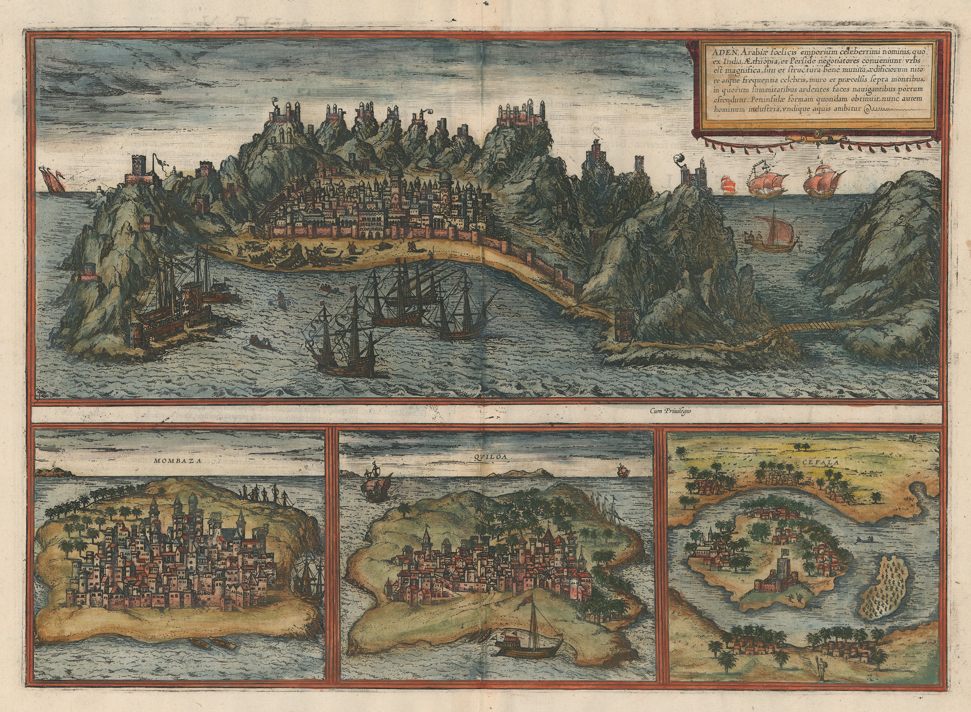
Georg Braun and Frans Hogenberg, Aden… Mombaza, Quiloa, Cefala [Arabia and East Africa Sheet], etching with applied color on paper, from Civitates Orbis Terrarum (1572). UTA Libraries Special Collections, Gift of Dr. Jack Franke
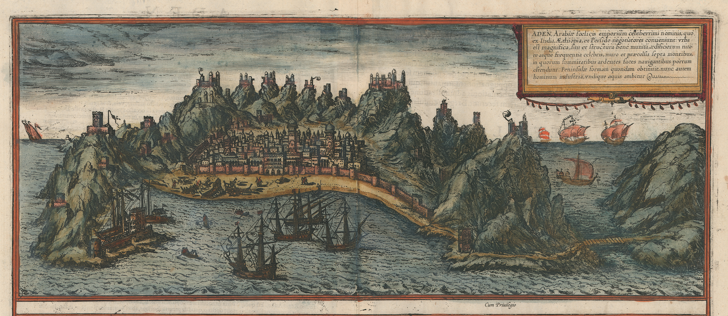
The view of Aden is similar to an earlier Flemish woodcut showing Portuguese forces attacking the city in 1513.
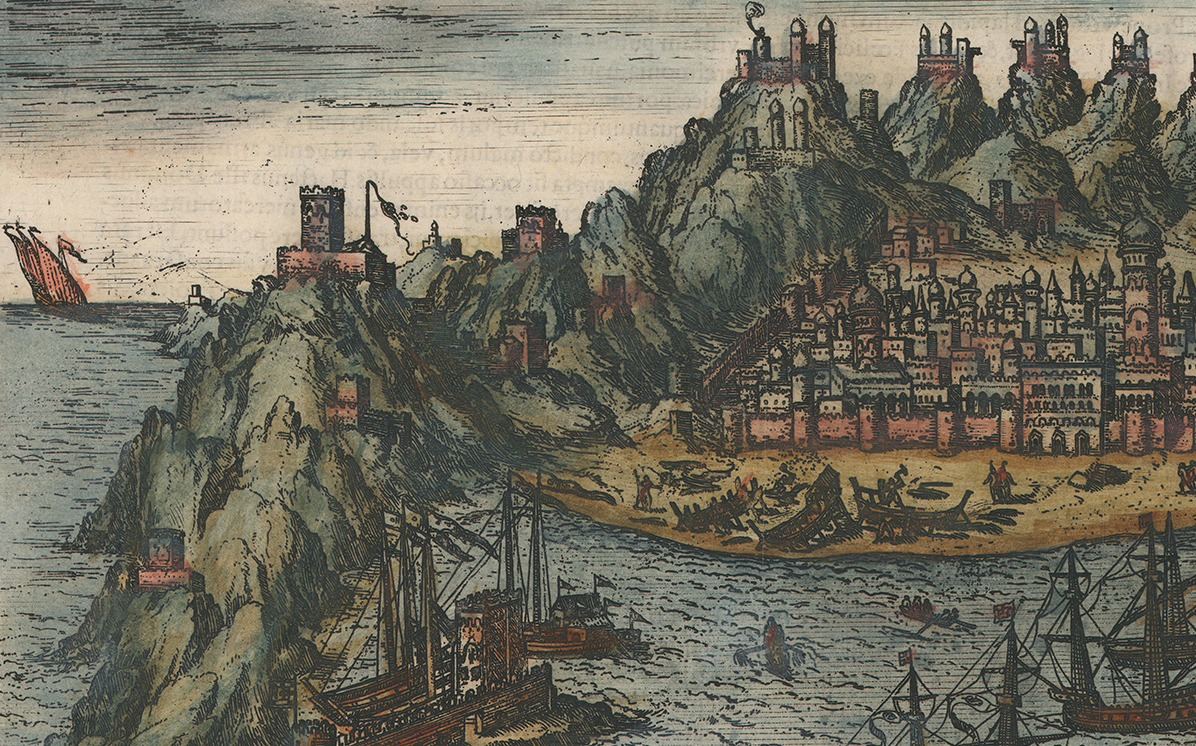
Aden, located on the Arabian peninsula along the Indian Ocean entrance to the Red Sea, is an ancient city with an interesting history. Zheng he’s Chinese fleet visited Aden in 1421. This detail shows the port facilities with vessels under construction.
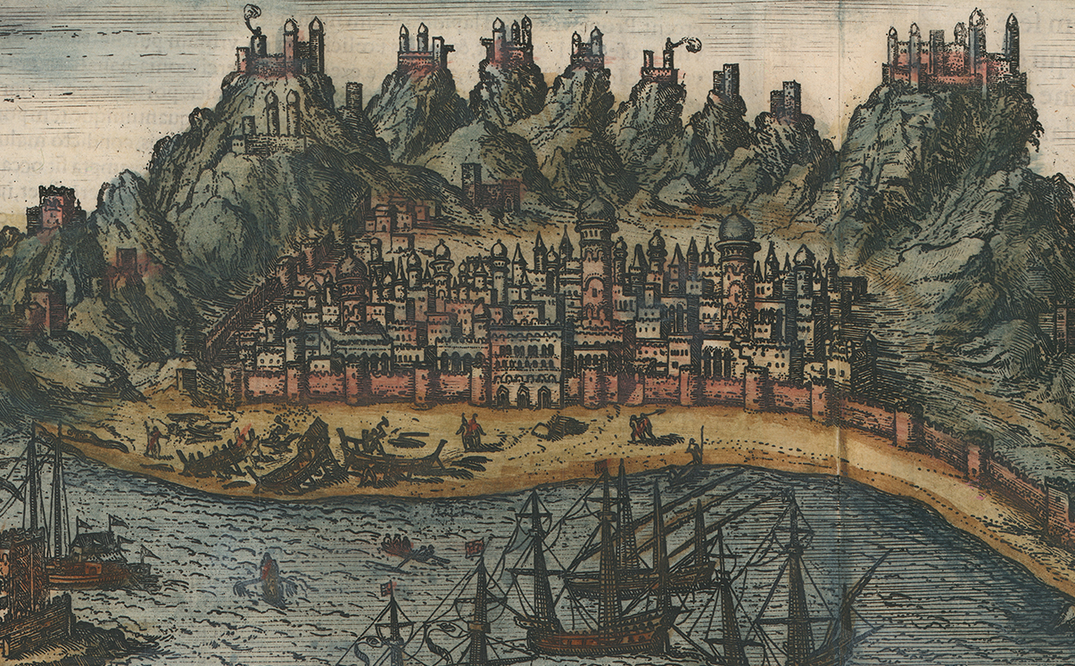
Aden (center detail). Portuguese agent Pero de Covilhã visited Aden in disguise on his way to India in the late 1480s before the Portuguese made the all-water route around west and south Africa.
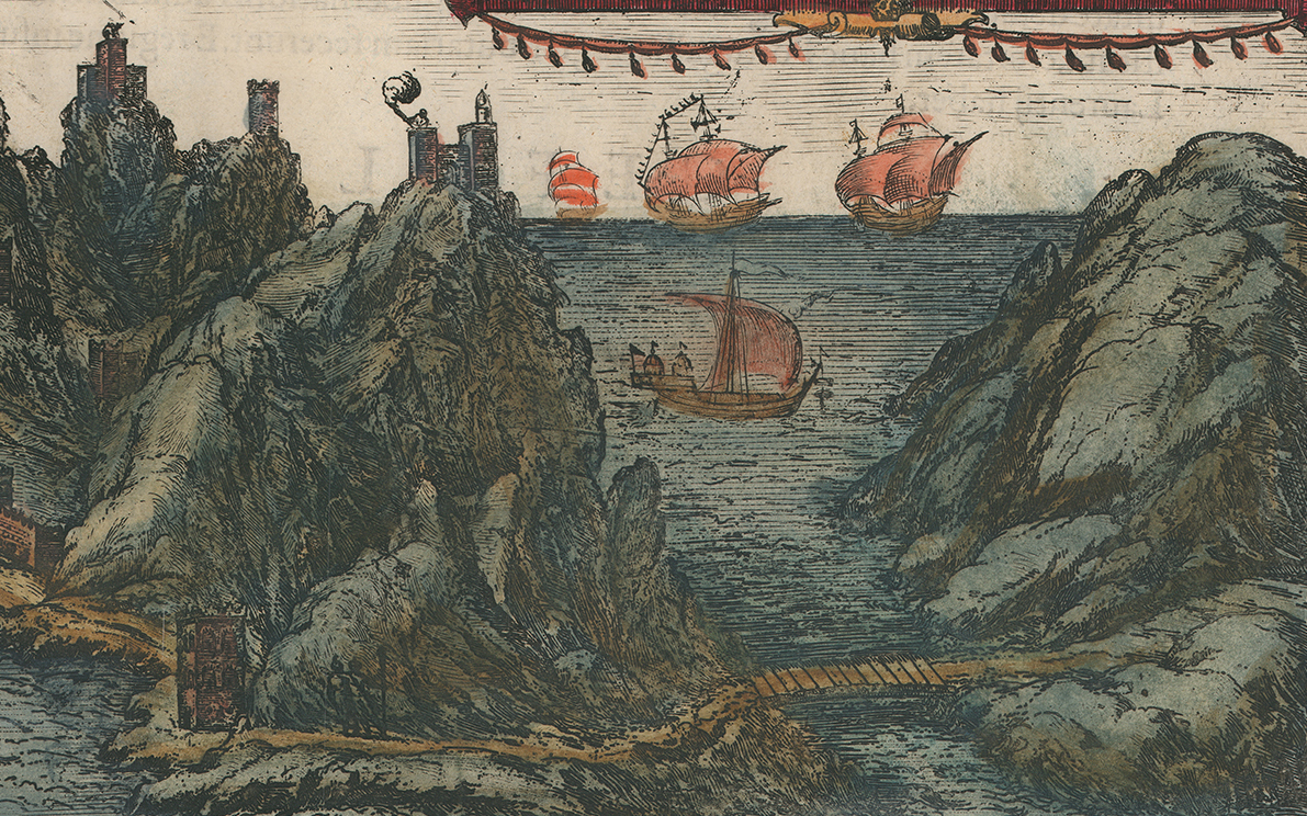
Aden (right detail). As alluded to earlier, the Portuguese, led by Alfonso de Albuquerque, attacked and looted the city in 1513.
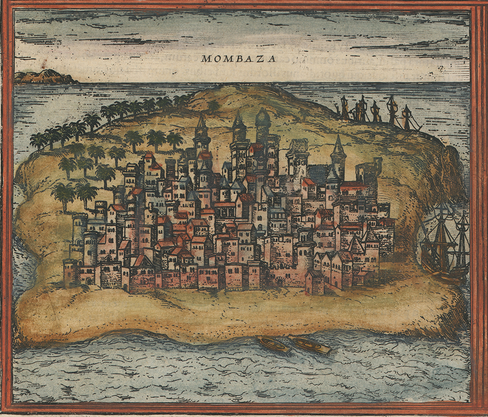
Mombasa dates to the 900s and its oldest Mosque dates from ca. 1300. The traveler and writer Ibn Battuta visited it ca.1330. The first known European there was Portuguese explorer Vasco da Gama in 1498. The Portuguese ruled it 1593-1698 and 1728-1729.
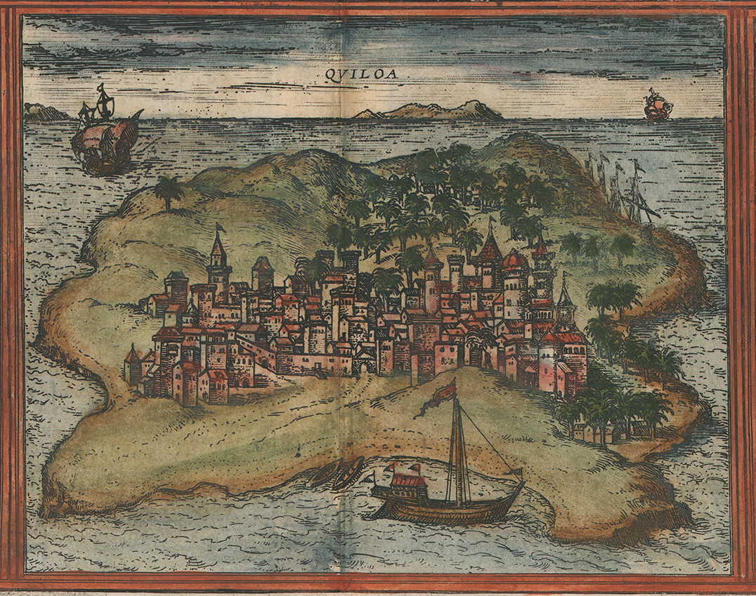
Quiloa (Kilwa Kisiwani, along the southern coast of present-day Tanzania) was the center of the Kilwa Sultanate whose power stretched along the entire Swahili coast of east Africa.
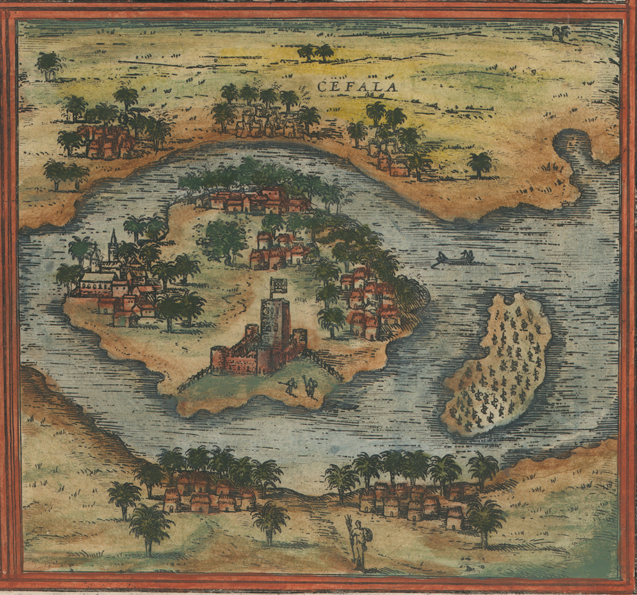
Covilhã, the Portuguese agent, visited Cefala (Sofala) on his way back from India. It was the principal trading port of the east African Mwenemutapa (Portuguese: Monomotapa) Kingdom in the 16th century.
All four views -- Aden, Mombaza, Quiloa, and Cefala -- ultimately derive from sketches made by Portuguese visitors who were among the first recorded Europeans in these areas since ancient times. Braun & Hogenberg probably based their view of Aden on an earlier Flemish woodcut that showed the 1513 Portuguese attack on that city. The views of Mombaza, Quiloa, and Cefala were part of the “towns of India, Asia, Africa and Persia, never portrayed before.” Braun also noted that the views were supplied by a correspondent and Hansa merchant named Constantin von Lyskirchen who apparently had access to an unidentified Portuguese illustrated manuscript.9
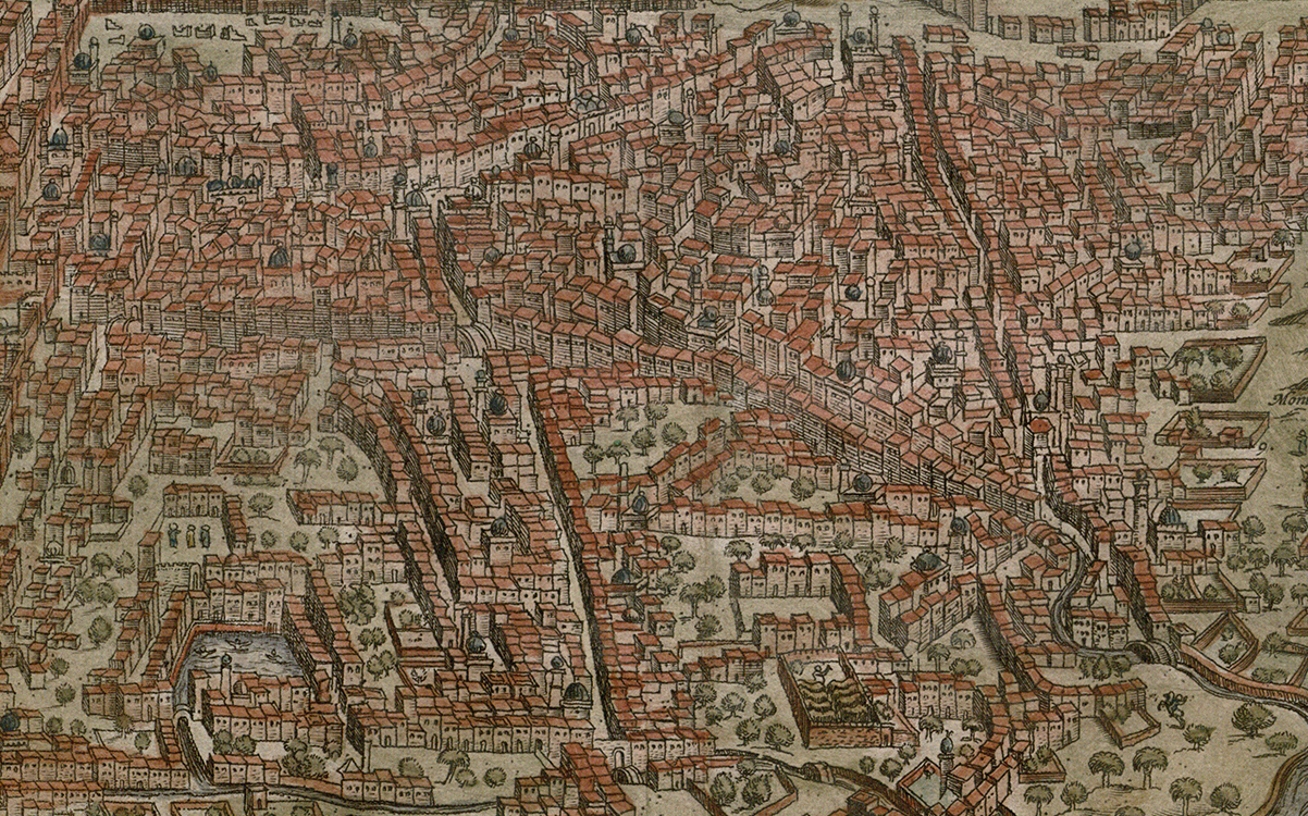
Braun & Hogenberg based their view of Cairo upon a large woodcut aerial view of the city originally compiled by Giovanni Domenico Zorzi and printed by the Venetian Matteo Pagano around 1546. The Zorzi/Pagano view was originally accompanied by a Latin text titled Descriptio Alchiriae written by Guillaume Postel. Authentic views of the city were so rare that Pagano’s view remained the standard view of the city available in western Europe for the next 250 years.10 The name “Babylon” in the title refers to the ancient fortress of Babylon on the Nile delta, located in an area known today as Coptic Cairo but also incorporated by old Cairo or the city of Fustat, founded in 751 by the Arab Muslim conquerors of Byzantine Egypt.
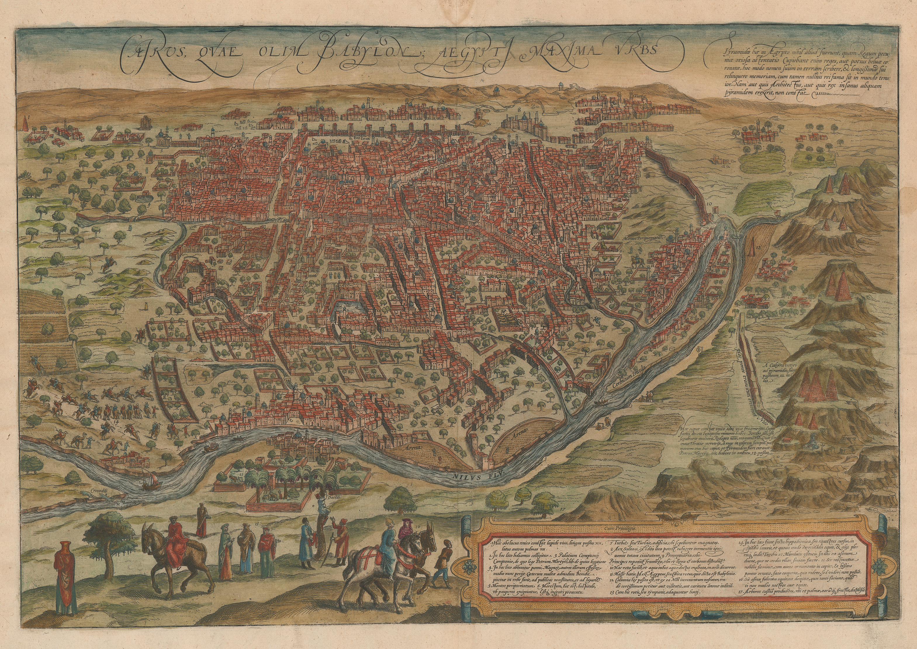
After Domenico Zorzi, Cairos, quae olim Babylon, Aegypt Maxima Urbs, etching with applied color on paper, from Civitates Orbis Terrarum (Cologne: Braun & Hogenberg, 1572). UTA Libraries Special Collections, Gift of Dr. Jack Franke
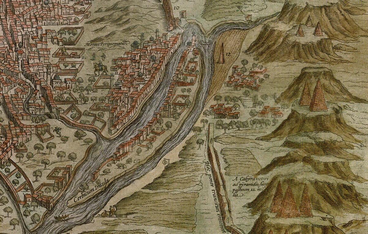
This detail shows old Cairo to the left of the island in the Nile River with several pyramids to the right. The old town incorporated the ancient fortress of Babylon and the town of Fustat, founded in 751 by the Arab Muslim conquerors of Byzantine Egypt.
No. 8 is the citadel, with the Turkish Sultan’s palace and the mosque of Suleyman Pasha, built in 1528. Part of the city walls, constructed primarily in the 11th and 12th centuries, may be seen to the left; the great citadel aqueduct is on the right.
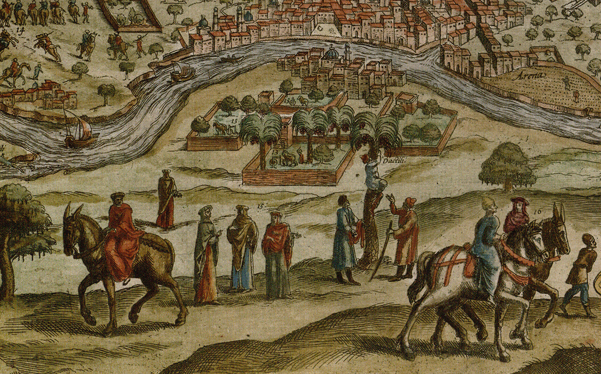
Foreground figures in local costumes before a suburb with gardens on the opposite bank of the Nile. Note the man climbing a palm to harvest dates.
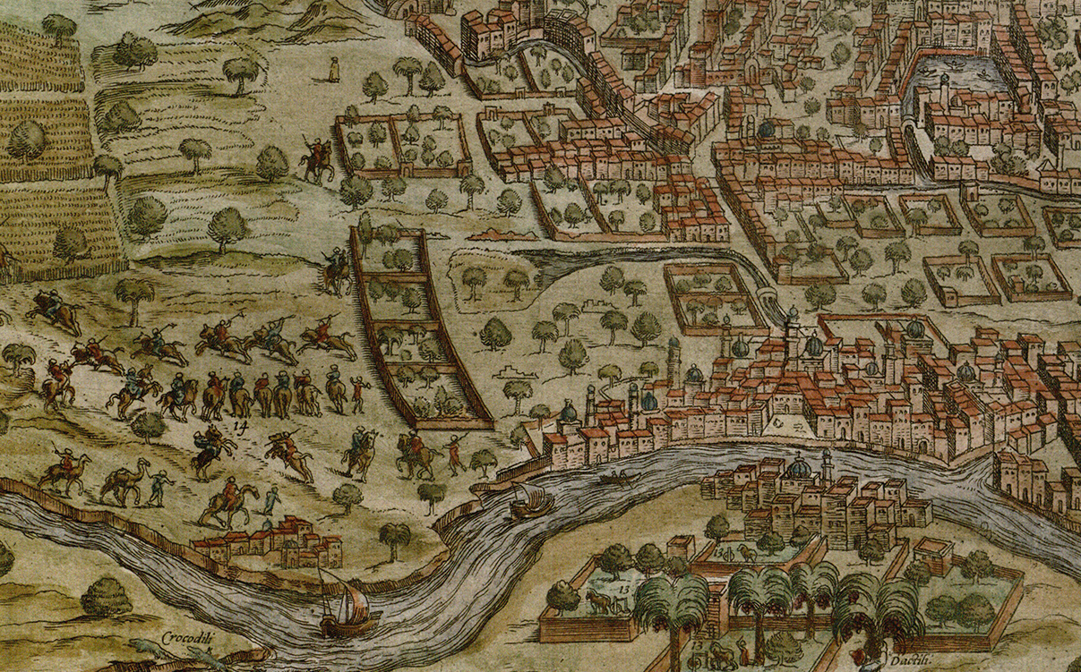
Detail of Cairo and Nile suburbs showing at far left two crocodiles and equestrian exercises, according to the key, in preparation for a hippo hunt.
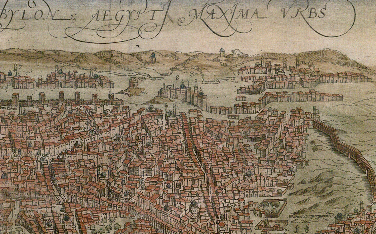
Detail of central Cairo showing dwellings, mosques, streets, and gardens.
The coloring on this sheet of five cities on the Moroccan coast demonstrates how widely differing color schemes could be applied to different sets of Braun & Hogenberg town views.
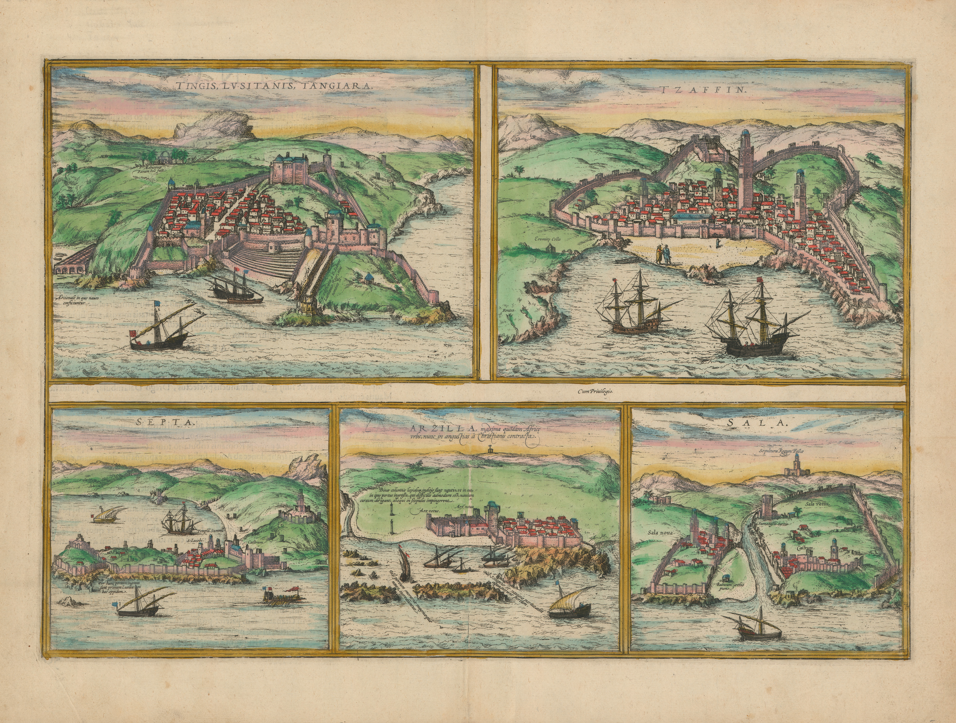
Tingis, Lusitania, Tangiara; Tzaffin; Septa; Arzilla; Sala. [Sheet with 5 Moroccan cities], etching with applied color on paper, from Civitates Orbis Terrarum (Cologne: Braun & Hogenberg, 1572). UTA Libraries Special Collections, Gift of Dr. Jack Franke

This detail from the previous sheet depicts the fortified city of Tangier, Morocco, which since 1471 had been under Portuguese control. Braun & Hogenberg's source for the view was probably an Italian engraving.
In the previous century the Portuguese attempted unsuccessfully to seize Tangier on three separate occasions and finally succeeded on a fourth in 1471. Portuguese attempts to create an empire in north Africa hindered their brief dominance in world trade.
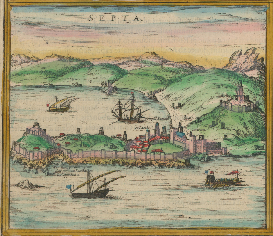
Septa (Ceuta) is located on the south side of the Mediterranean near the eastern entrance to the Straits of Gibraltar. The Portuguese established their first foothold in Africa there in 1415 and remained until 1640, when replaced by the Spanish.
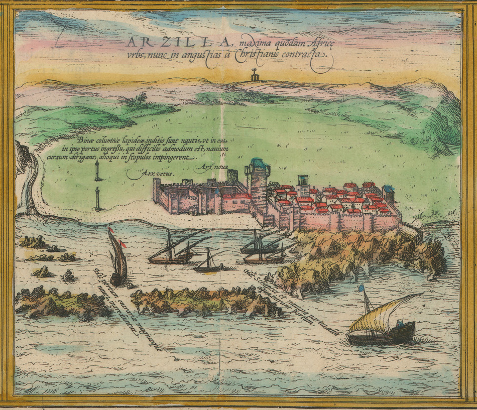
The Portuguese first occupied Arzilla (Asilah), located on the Atlantic coast of northern Africa, in 1471. They later used it as a base in an attempt to expand into the rest of Muslim Morocco.
Braun & Hogenberg's view shows older and newer fortifications, the channels by which ships and small boats entered the port, and stone columns used as landmarks by pilots to navigate.
After the death of Portuguese King Sebastiao at the Battle of Alcacer Quibir, control of Asilah alternated between the Moroccans and the Spanish. Today it is part of Morocco.
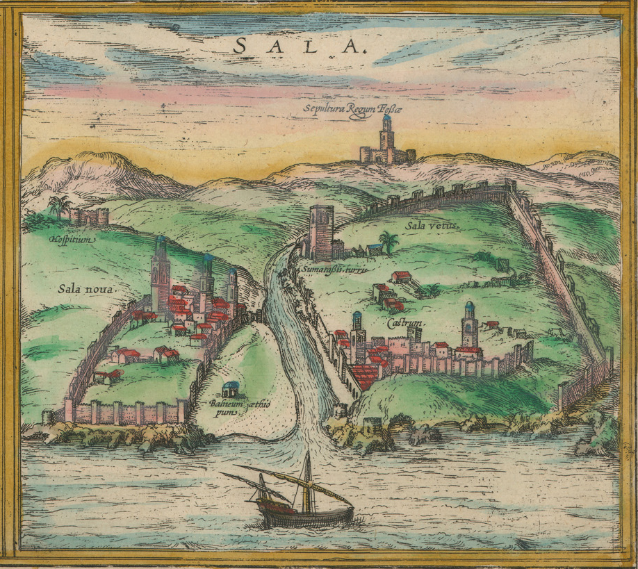
This view depicts Sala vetus (Salé, or literally old Sala) and Sala nova (today the Moroccan capital of Rabat) located on the Bou Regreg River. Sala vetus features a large city wall, castle, and towers.
Sala nova has structures beyond its walls labeled Balineum aethiopum (“Ethiopian Bath”) near the river and Hospitium (“hospital”) at far left. In the distance at right is the Sepultura Regum Fessae ("Monument to the King of Fez").
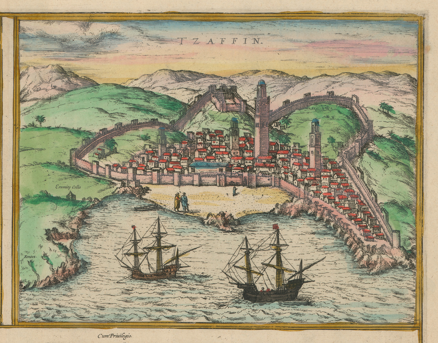
Safi, today in Morocco, which the Portuguese occupied between 1488 and 1541. After that time the port city became something like an international free-trade zone with one of the safest harbors in north Africa.
Almost every Braun & Hogenberg city view attests to the violent nature of much of life in the late 16th century. Cities and towns required massive fortifications for protection. Even outwardly peaceful looking views contain details alluding to this violence or, at the very least, the predilection of artists to show such scenes. The struggle between western European Christian forces led by Spain and the Islamic forces led by the Ottoman Turks for control of the Mediterranean is a major theme of Braun & Hogenberg's views of Mediterranean cities in North Africa.
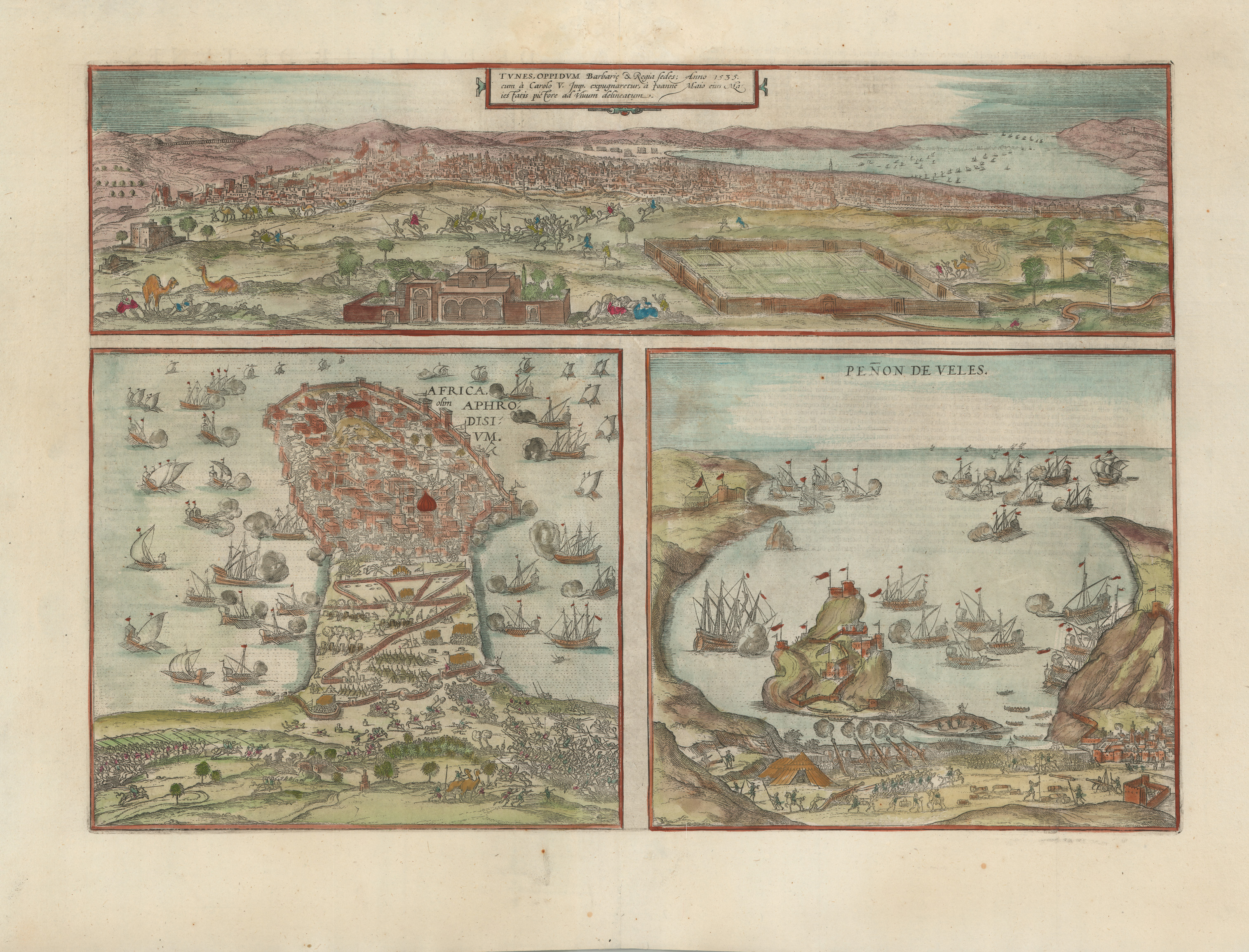
Tunis Oppidum...; Africa Aphrodisium; Penon de Veles [Sheet with 2 Tunisian cities and a fort on the Mediterranean coast], etching,from Civitates Orbis Terrarum (Cologne: Braun & Hogenberg, 1575). UTA Libraries Special Collections, Gift of Dr. Jack Franke
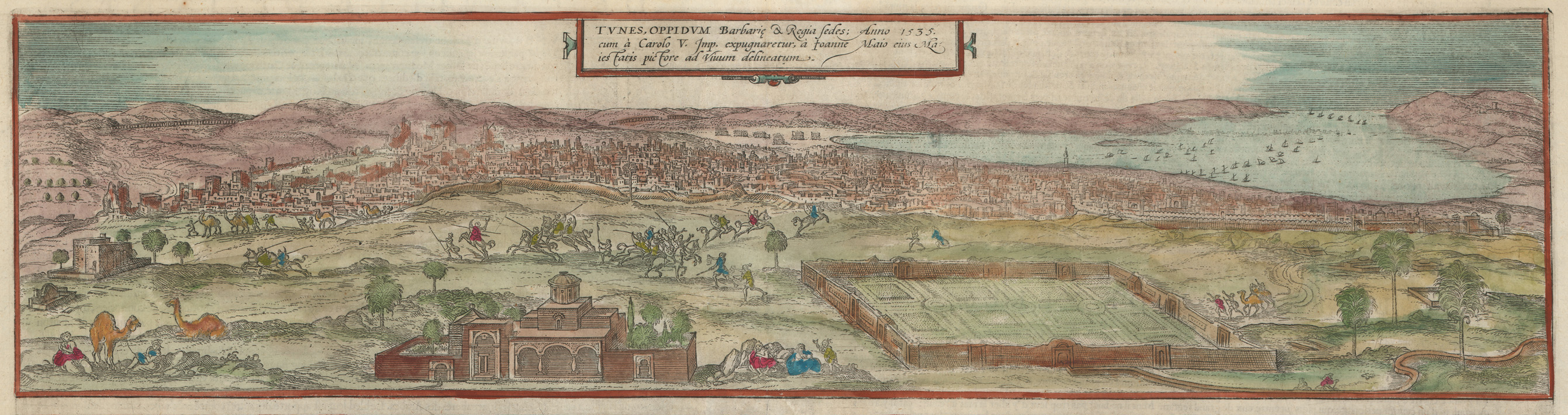
Braun & Hogenberg based this view of Tunis upon a work by Jan Cornelisz Vermeyen (Joanne Maio) (ca.1504-1559), a court painter who accompanied Holy Roman Emperor Charles V during his capture of the city in 1535.
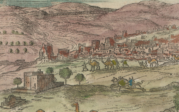
Vermeyen's view included the city walls, an aqueduct, palm trees, and camels that must have seemed very exotic to Europeans.
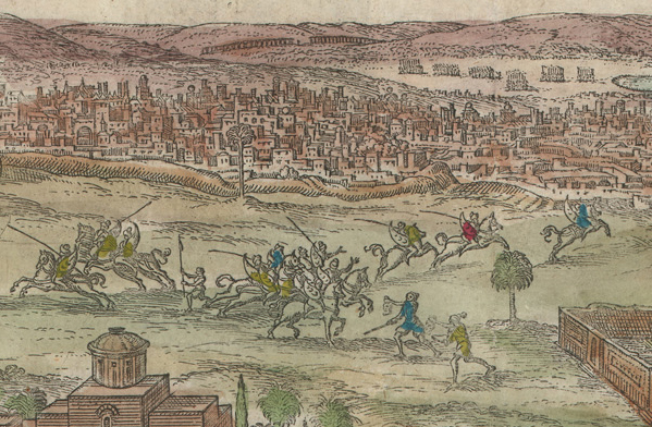
Turban-clad Muslim cavalry scamper about as two figures bearing scimitars and severed heads return from a conflict in triumph in the central foreground of Vermeyen's view of Tunis.
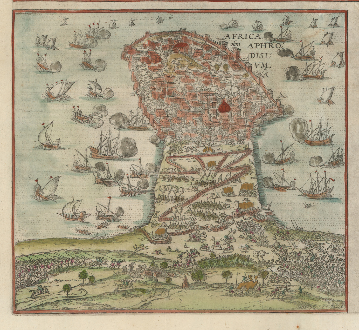
Africa Aphrodisium relates to the Tunisian city of Mahdia, which was captured by the Spanish in 1550. Based upon a woodcut in a book by Juan Christoval Calvete titled De Aphrodisio expugnata [The Storming of Aphrodisum] published in Antwerp in 1551.[3]
Detail of the attack on Aphrodisium showing siege operations by land and naval forces. Vessels include larger lateen-rigged carracks, caravels, or galleons, and smaller galleys, galiots, or Barbary fustes and xebecs with a mix of oars and sails.
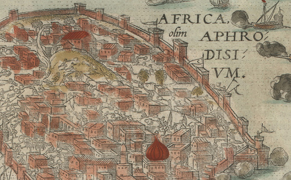
Christian and Muslim forces battle in the streets of Aphrodisium. Incidentally, the Spanish soon left the city in 1553 when they realized that continuing to hold it was too expensive.[4]
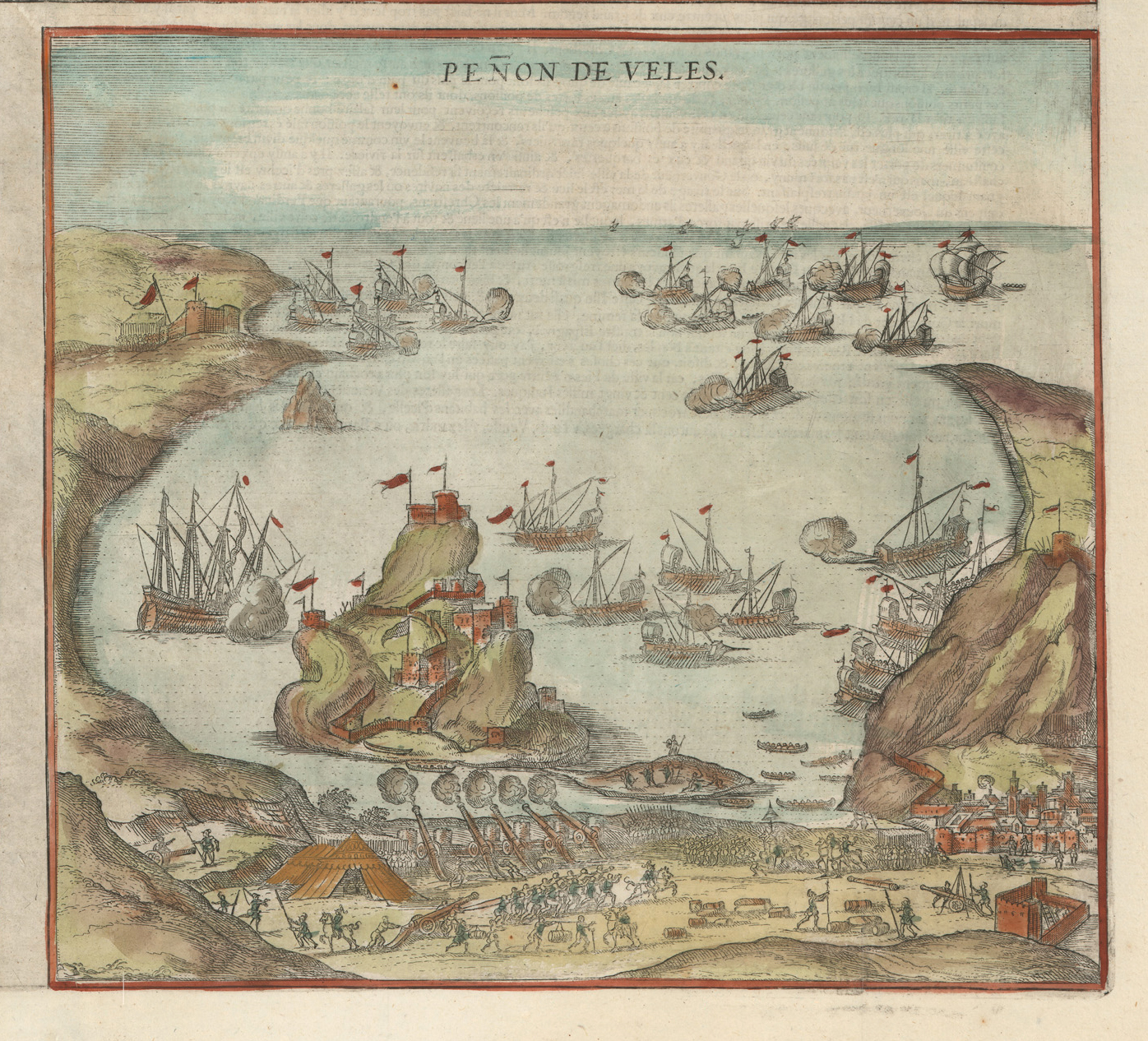
Peñon de Veles was drawn from an image by either Giovanni Francesco Camocio or Ferrando Bertelli, both Venetian map and printmakers.[5] The Peñon, located on the Mediterranean coast of Morocco, was a haven for Berber corsairs in the early 15th-century.
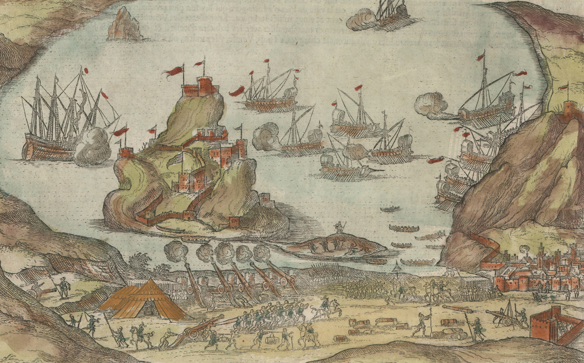
The rocky fortress, constructed by the Spanish beginning in 1508, changed hands on several occasions. This detail shows Spanish artillery in the foreground bombarding the city when the Spanish retook it from local Berbers in 1564.
The Peñon is still administered by Spain and is generally reached by helicopter today.
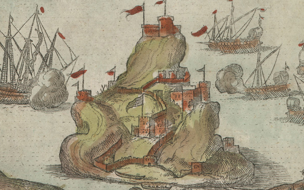
Braun and Hogenberg’s view of Algiers, seen below in this uncolored example, is an update of a view originally sketched during the unsuccessful Spanish siege of the city personally led by Emperor Charles V in 1541. The sketch was first printed by Antonio de Salamanca and other engravers before Braun & Hogenberg's update.11 As in the first Antwerp view with its large foreground figures in local costume, the view of Algiers features a Turkish sultan or noble in full regalia with turban and tunics or robes. Incidentally, some of the sources for the costumed figures included in the Braun & Hogenberg prints were illustrated books that specialized in costumes or clothing such as Abraham de Bruyn's Omnium poene gentium imagines (Antwerp, 1577) and Omnium pene... gentium habitus (Antwerp, 1581) or Hans Weigel and Jost Amman's Trachtenbuch (Nuremberge, 1577).12
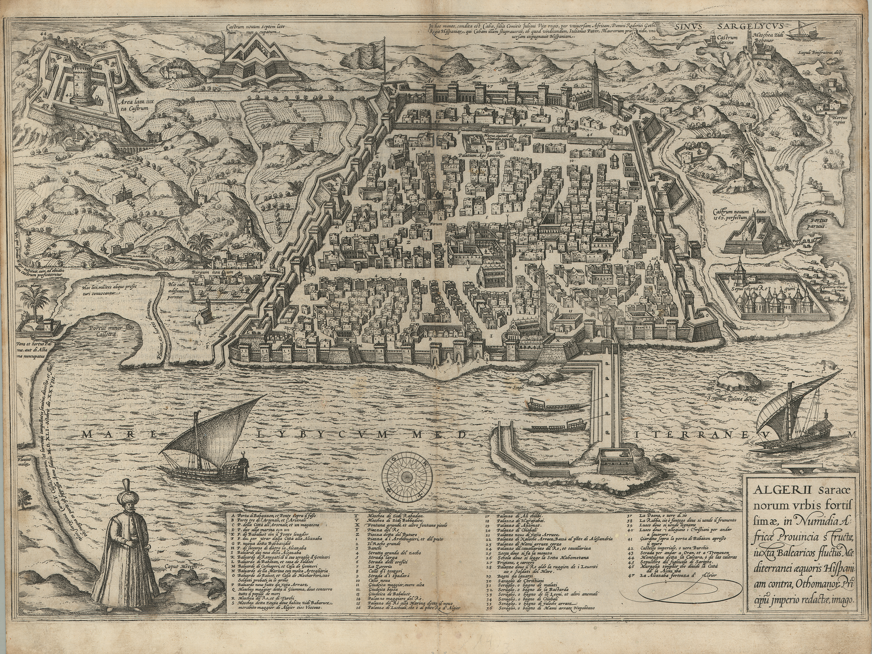
Georg Braun and Frans Hogenberg, Algerii...[Algiers], etching on paper, from Civitates Orbis Terrarum, Book II (Cologne, 1575). UTA Libraries Special Collections, Gift of Dr. Jack Franke
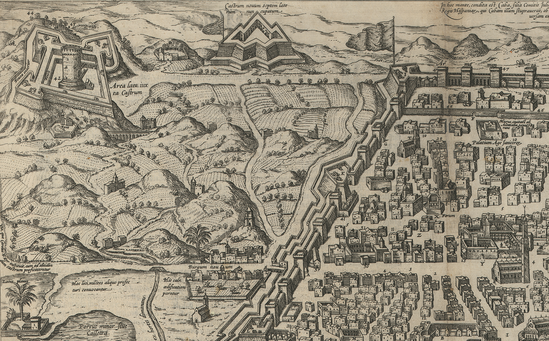
Detail 1 of Braun & Hogenberg's view of Agliers from 1575 showing fortifications, city walls, dwellings, and streets.
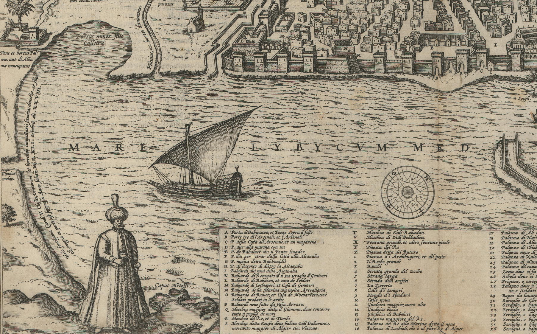
Detail 2 of Braun & Hogenberg's Algiers from 1575 features a large figure (either an Ottoman Turkish sultan or local official) in tunics or robes and turban. Text at left references Charles V's siege and the storm that devastated his forces.
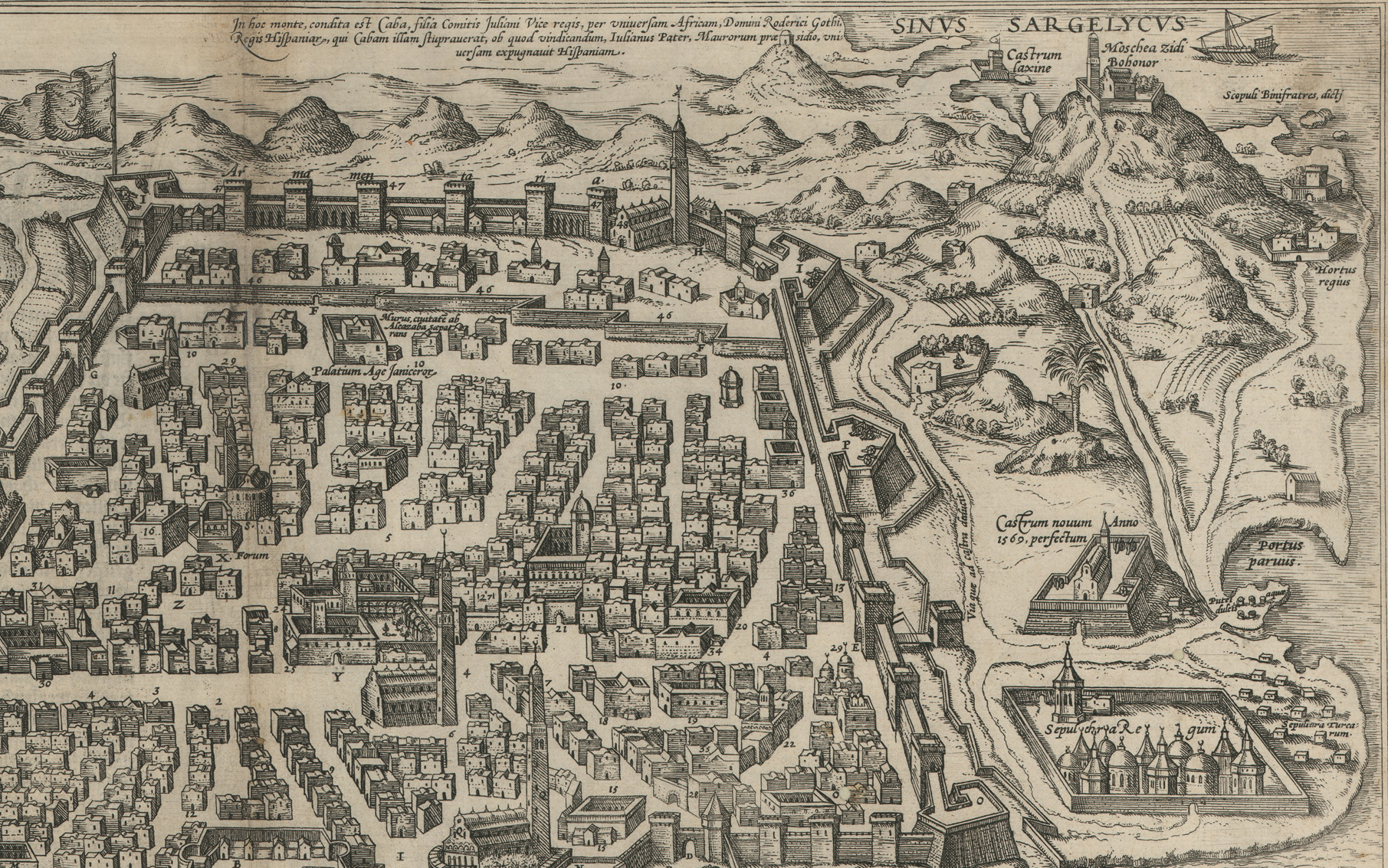
Detail 3 from Braun & Hogenberg's Algiers shows a variety of structures, including a new fort constructed since the siege, in 1569.
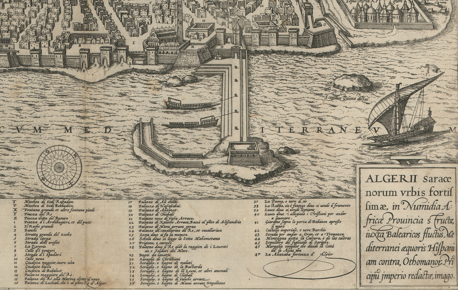
This detail from Braun & Hogenberg's Algiers (1575) continues the descriptive key and shows port structures. Note the vessel with a combination of oars and sails, similar to galleys and galiots used in the Mediterranean, the Berber version was a "fuste."
Like other atlases and illustrated books at the time, patrons apparently bought the Civitates volumes as issued uncolored and could either leave them that way or take them to a colorist. In many cases the views were colored hundreds of years after their publication; sometime, to best determine "original color" or "old color" it may be necessary to make a chemical analysis.
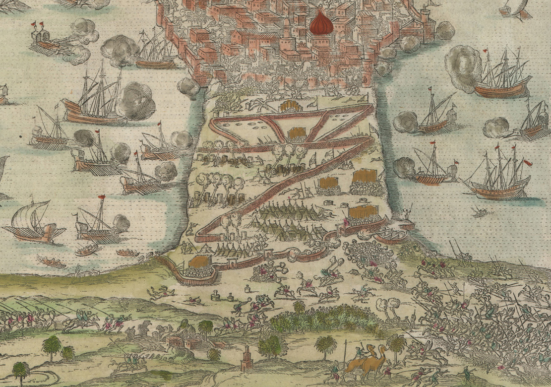
The following view from Book II, first published in 1575, depicts an important contemporary event of considerable significance: the Ottoman Empire’s victory over the Spanish Empire at the siege of Tunis and port of La Goulette (Haiq al-Wadi, also in present-day Tunisia) in 1574 during their struggle for control of the Mediterranean.13 As it turned out, the recapture of Tunis by the Ottoman Turks finally ended the Spanish conquista of North Africa that had begun after the fall of Granada in 1492 and, as a result, kept north Africa under Muslim rather than Christian control for centuries.
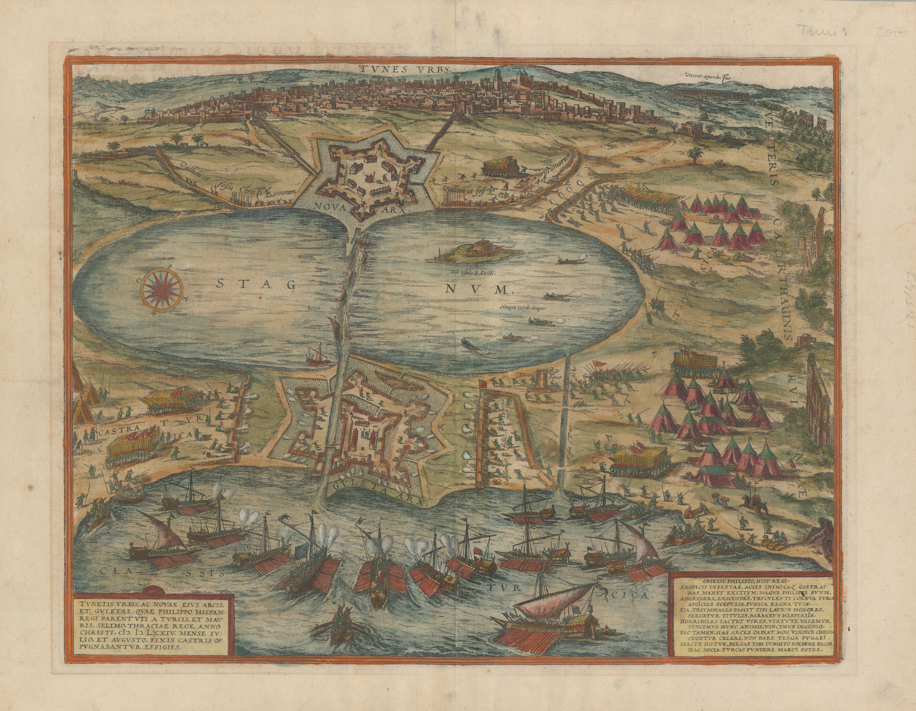
Georg Braun and Frans Hogenberg, Tunetis Urbis...[Tunis besieged by the Ottomans in 1574], from Civitates Orbis Terrarum (1575). UTA Libraries Special Collections, Gift of Dr. Jack Franke
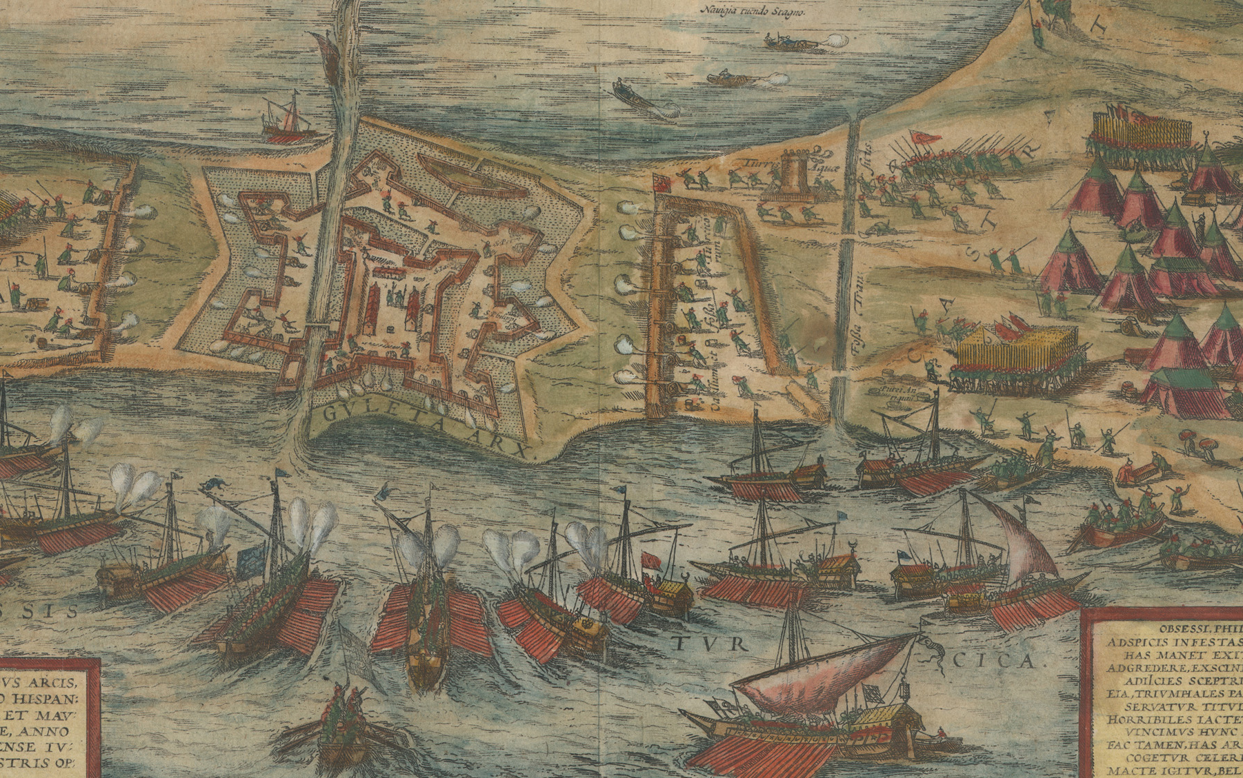
In this detail, Turkish navy galleys, many of them constructed after the Turkish defeat at the battle of Lepanto in 1572, together land forces drawn from the forces of neighboring cities, attack the Holy League-held Guleta Arx or citadel of La Goulette.
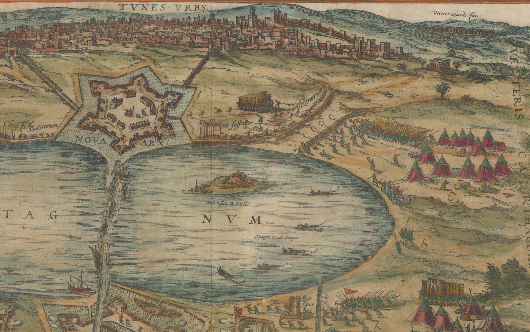
Ottoman forces attack the Holy League troops occupying the Nova Arx or new citadel lying beyond the stagnant lake before the distant walled city of Tunis. La Goulette fell first, resulting in the capture of thousands of Spaniards and their allies.
Subsequent European artists, engravers, and publishers continued to copy Braun & Hogenberg's city views, often without credit, for many years after their first publication.14 Their influence was widespread and remained significant at a time when European travel to Africa was quite limited.
1 Braun & Hogenberg Civitates Orbis Terrarum 'The Towns of the World,' with an introduction by R. A. Skelton (3 vols.; Cleveland and New York: The World Publishing Company, 1966).
2 Skelton, "Introduction," in Braun & Hogenberg Civitates Orbis Terrarum (1966), pp. vii-xi. Hogenberg was the son of an engraver from Munich who had settled in Mechelen or Malines. Frans studied engraving with his stepfather, the Dutch master Hendrik Terbruggen, and then, at the age of 20, accompanied Gerhard Mercator and Abraham Ortelius on a trip to France. Mercator, of course is the famed cartographer and inventor of the map projection that bears his name. Mercator was the first to use the term "atlas" for a compilation of maps. Although there were earlier books of maps, Ortelius’s Theatrum had maps representing the entire world in a similar format throughout. See also Peter H. Meurer, "Cartography in the German Lands, 1450-1650," in David Woodward et al, ed., The History of Cartography: Volume Three Cartography in the European Renaissance (Chicago and London: The University of Chicago Press, 2007), part Ii, pp. 1234-1236.
3 Skelton (1966), p. ix; Meurer in The History of Cartography Volume Three (2007), part 2, p. 1234, more specifically states that Hogenberg was of the Calvinist persuasion.
4 On the 16th-century map and print trade in the southern and northern Netherlands see Kees Zandvliet, Mapping for Money (Amsterdam: Batavian Lion International, 1998) and Cornelis Koeman, Günter Schilder, Marco van Egmond, and Peter van der Krogt, "Commercial Cartography and Map Production in the Low Countries, 1500-ca.1672," in Woodward et al, ed., The History of Cartography: Volume Three (2007), part 2, pp. 1296-1383.
5 Skelton (1966), pp.x-xiv; Henk Deys et al., Guicciardini Illustratus: De kaarten en prenten in Lodovico Guicciardini's Beschrijving van de Nederlanden ('t Goy-Houten, Netherlands: Hes & De Graaf, 2001), pp. 127-131.
6 Skelton (1966), pp. xii, xxxi; Deys et al., Guicciardini Illustratus (2001), pp. 126-127.
7 Skelton (1966), pp. x-xi.
8 Skelton (1966), pp. xlii-xliii.
9 Skelton (1966), p. xlii. UTA's engraving was printed from the second state, published in 1574, according to Peter van der Krogt, Koeman's Atlantes Neerlandici: New Edition, vol IV (Houten, Netherlands: Hes & De Graaf, 2010), IV-2, p. 676.
10 Skelton (1966), p. xlii. On Zorzi, see Robert W. Karrow, Jr., Mapmakers of the Sixteenth Century and Their Maps (Chicago: Newberry Library and Speculum Orbis Press, 1993), pp. 612-616. UTA's engraving is from the second state, published in 1572, 1574, or 1575, according to Van der Krogt (2010), vol. IV-2, pp. 802-803.
11 Skelton (1966), p. xlii. Interestingly, Charles V’s siege was a disaster for the Spanish despite his large force and the presence of many of his most illustrious military commanders, including Hernan Cortes, recently returned from Mexico. The intervention of the Knights of Malta spared Charles V himself from capture, but thousands of his men were killed or captured and later sold as slaves.
12 Skelton (1966), p. xvii.
13 Skelton (1966), p. xliii, stated that Braun & Hogenberg's view was "after an Italian engraving of the Imperial attack on Tunis in 1573." The troops attacking the Christian-held forts in Braun & Hogenberg's view are clearly Muslim or Ottoman Turkish as seen by their ships, weapons, and costumes, suggesting this may be said more correctly to depict the successful Ottoman counterattack of 1574.
14 For example, Johannes Janssonius acquired the plates for Braun & Hogenberg's Civitates Orbis Terrarum from Abraham Hogenberg around 1653 or earlier, incorporating most of them into his own 500-plate Theatrum urbium or Town Atlases, published in Amsterdam in 1657. See Van der Krogt, Koeman's Atlantes Neerlandici: New Edition, vol. IV-1 (2010), pp. 262-287.
Comments
2nd edition
After all I don't know when was published a second edition, if around 1653, or at 1966, Skelton, or if is another one.
Add new comment