
by Ben Huseman
by Ben Huseman
The purpose of The Compass Rose is to raise awareness of Special Collections' resources and to foster the use of these resources. The blog series also reports significant new programs, initiatives, and acquisitions of Special Collections.
We are happy to report that last year Mr. Lee Greenhouse of Chicago selected The University of Texas at Arlington Libraries Special Collections as the place to donate his personal collection of fourteen exquisite antique maps. The maps fit Special Collections’ collecting area relating to the history of cartography, but they are well outside our usual focus on Texas, the southwestern United States, Mexico, the Gulf of Mexico, and the Caribbean. In fact, during the past few years UTA Libraries Special Collections has carefully broadened its collecting scope to include some materials that better serve the incredibly diverse interests and backgrounds of members of the University and rapidly growing DFW population. The earlier cartographic collections’ focus on Texas, the Southwest, Mexico, the Gulf of Mexico, and the Caribbean is still emphasized, but it is hoped (and already also proven) that new areas of collecting will also attract new classes, scholars, and visitors. Over 5,000 of UTA’s maps, many of which came from the marvelous Virginia Garrett Map Collection, are already available on the web through UTA Libraries Cartographic Connections “Libguide” and The Portal to Texas History. And since last year, more digital images of UTA’s amazing collections of maps are appearing in UTA Libraries Digital Gallery Beta. The Africa Map Collection of Dr. Jack Franke has been steadily arriving here since 2018 and already constitutes over 400 items. Parts of it are already available in UTA Libraries Digital Gallery and through a growing Maps and Images of Africa “Libguide.” We also plan to feature items from it as well as other acquisitions (both older and recent) in upcoming Compass Rose blog posts. So, while the fourteen maps of the Lee R. Greenhouse and Flora E. Lazar Map Collection may sound relatively small, they are maps of considerable significance. They also represent areas of the world not normally collected by UTA Libraries Special Collections but they nevertheless fit and complement our growing collections and interests perfectly.
The oldest map in this new gift is a finely hand-colored woodcut map of India published in 1513 in Strassburg (now spelled Strasbourg, located in northeastern France):
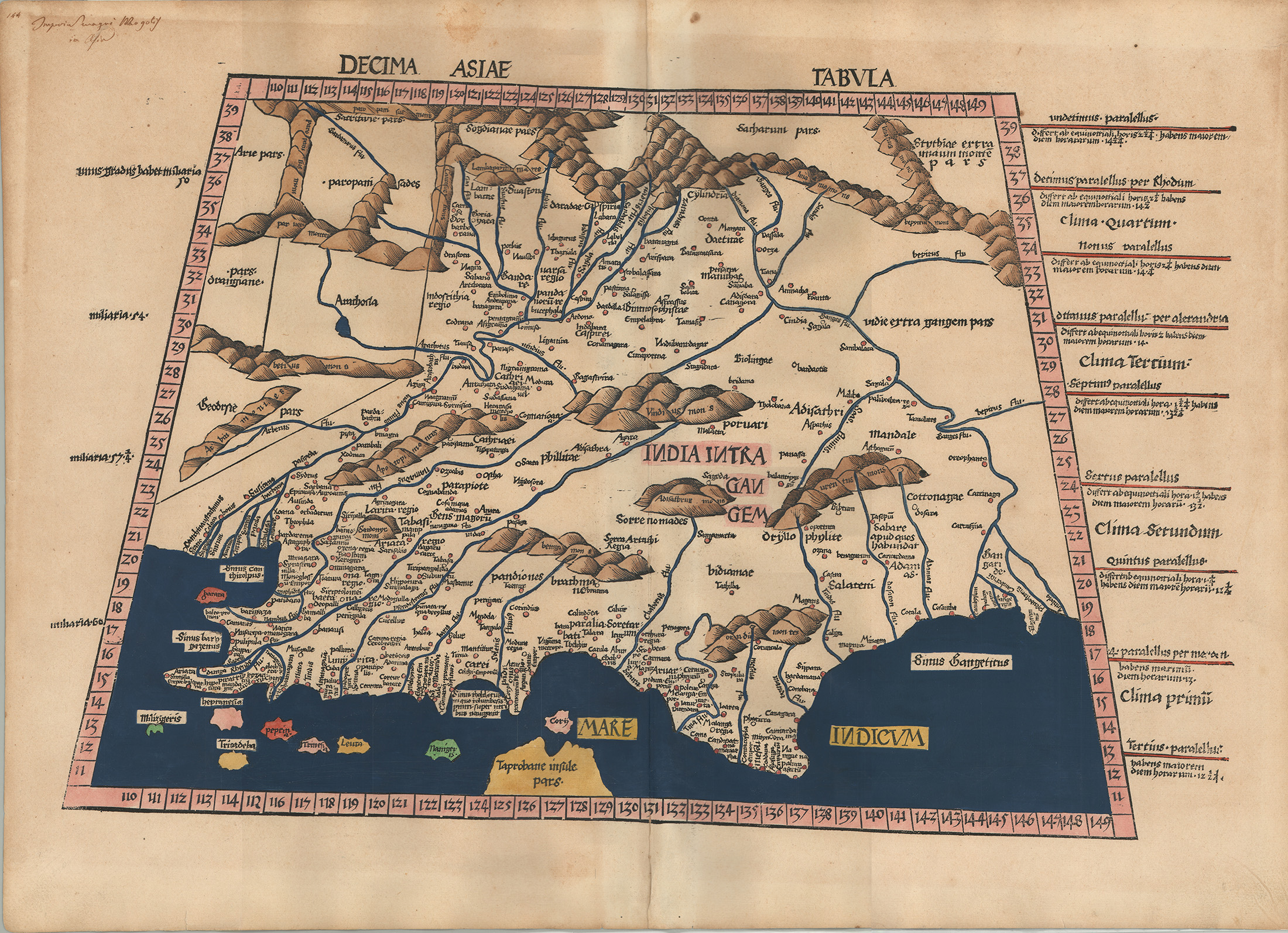
Geographer and cartographer Martin Waldseemüller constructed the map according to methods and information passed down through the centuries in the Geography written by Claudius Ptolemy, a second-century Greek geographer and scholar working in Alexandria, Egypt. This regional map, the tenth of twelve maps of Asia based upon Ptolemy’s work, was drawn upon a trapezoidal projection and includes numbers around the edges for the mathematical coordinates of degrees of latitude and longitude.1 Western geographical knowledge of the East was obviously quite limited, having to rely upon ancient sources. Waldseemüller, by the way, is the same cartographer who created the 1507 world map that first named the continent America after Amerigo Vespucci.2
Antwerp-based atlas creator Abraham Ortelius’ map of China first published in 1584 is now represented in UTA’s growing collections by an original engraving on paper with original hand color from the first Spanish edition of Ortelius’ atlas published in 1588:
![Abraham Ortelius / Luiz Jorge de Barbuda, Chinae... [China], from Abraham Ortelius, Theatro de la Tierra Universal… (Antwerp, 1588; first published in 1584). Gift of Lee R. Greenhouse and Flora E. Lazar](/sites/default/files/inline-images/02_20112641A_med_0.jpg)
The Spanish text on the back of the map helps identify and date the edition.3 At the time, Ortelius’ map was the most accurate map of China available in the West and it was the first European printed map to show the Great Wall. Ortelius directly credited his Portuguese source for this map: Jorge Luiz de Barbuda, a scholar in Lisbon who had access to information from Portuguese traders and Portuguese Jesuit missionaries.4 Portuguese traders had first reached China by sea in 1513 and Portuguese Jesuit missionaries had established their headquarters for China and Japan at the trading port of Macao at the mouth of the Pearl River in 1563. Unfortunately, Jorge Luiz did not record what Chinese maps he may have used. The map, oriented with west at the top, contains some interesting details and inscriptions in addition to decorations consisting of Flemish Mannerist strapwork, fruit, birds, and cherubs or putti. In several places on the land there are elephants, deer or elk, Mongolian nomadic tents or yurts (gers), and sail cars or land yachts – an older Chinese invention that gained popularity in Europe at this time.5 A couple of European ships and what appears to be a shark cruise offshore.
The Greenhouse/Lazar gift includes three maps of Japan. The first of these is Japonia, a hand-colored map engraved on copperplate by Jodocus Hondius and first published in Amsterdam in 1606:
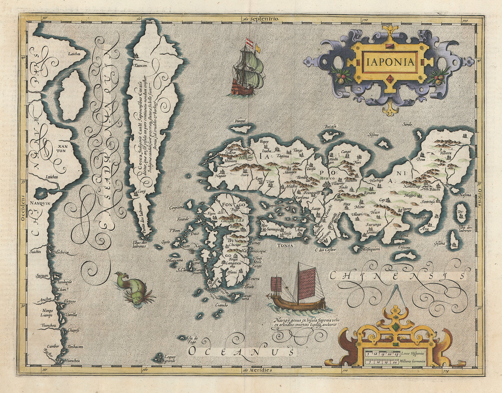
Hondius derived his information from Ortelius who in 1595 had first published a map of Japan acknowledged as the work of Portuguese mathematician and cartographer Luis Teixeira (active 1564-1604).6 Portuguese merchants had been shipwrecked on the island of Kyūshū as early as 1543 and the first Portuguese Jesuit missionary had arrived just two years later. Hondius’ map was largely identical to the Ortelius/Teixeira map but Hondius added his own ornamental Mannerist-style strap-work cartouches for the title and scale guide and substituted a sea monster and a two-masted Japanese or Chinese junk for a couple of the Portuguese-style merchant carracks or galleons.
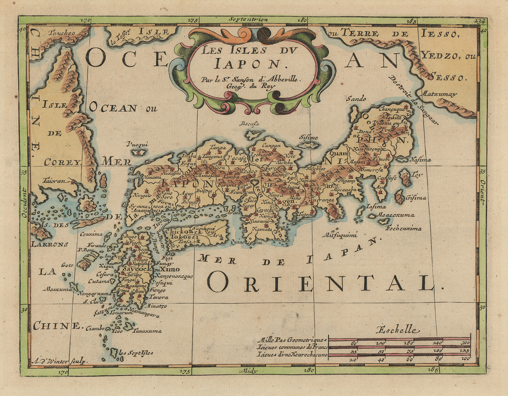
French cartographer Nicolas Sanson’s Les Isles du Japon, was first published in Paris in 1562. It was based upon a European map of Japan of the “Dudley / Janssonius type” identified by cartographic scholar Lutz Walter as first published in Florence by the English explorer and cartographer Sir Robert Dudley in 1647 and further elaborated by the Dutch cartographer Janssonius in 1651. Dudley had used the “Ortelius/Teixeira type” of map of Japan along with Jesuit sources and Janssonius apparently used Dudley’s map and some Dutch East India Company (VOC) manuscripts.7 The example here was re-engraved by Antonie de Winter and re-issued in Utrecht under Sanson’s name in 1683.8
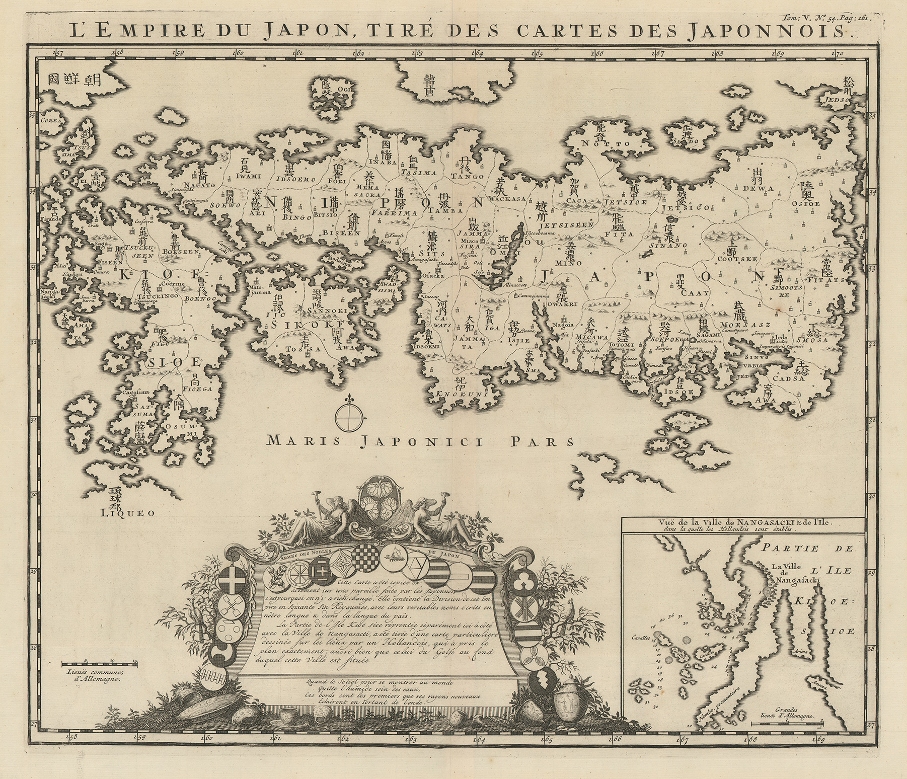
Henri Abraham Chatelain, L’Empire du Japon, Cartes des Japonois, engraving on paper, Amsterdam, 1719. UTA Libraries Special Collections, Gift of Lee R. Greenhouse and Flora E. Lazar
The third map of Japan, Henri Abraham Chatelain’s L’Empire du Japon, Cartes des Japonois, was apparently based upon Walter’s “Reland type” of European map of Japan first published in Amsterdam in 1715 by Dutch Orientalist scholar Aadrien Reelant accompanying Frederic Bernard’s Receuil de voiages au nord [Collection of Travels to the North]. For the main map of Japan Relant had copied a 1691 Japanese woodcut map by Ishikawa Ryūsen in the possession of the VOC. Particularly interesting are Chatelain’s inclusion of sixty-six provinces, his effort and claim to have copied and transcribed the Sino-Japanese characters unchanged (although he made mistakes), a Baroque cartouche with the arms of Japanese noble families, and Relant’s inset map of the area around Nagasaki where the Europeans had been active.9
These new gifts allow us to engage people with interests outside our normal collection focus. The gifts should also allow us to gain greater global perspective on our wealth of collections of more local interest and concentration.
1 Claudius Ptolemy, and R. A. Skelton. Ptolemaeus, Geographia. Strassburg, 1513. (Amsterdam: Theatrum Orbis Terrarum, 1966). Ptolemy did not himself originate the numbering system, but in turn based it upon the work of other fellow ancient Greeks, including Eratosthenes of Cyrene, Hipparchus of Nicea, and Marinus of Tyre.
2 Robert W. Karrow, Jr., Mapmakers of the Sixteenth Century and Their Maps: Bio-Bibliographies of the Cartographers of Abraham Ortelius, 1570 (Chicago, Speculum Orbis Press, 1993), pp. 568–583.
3 Marcel van den Broecke, Ortelius Atlas Maps: An Illustrated Guide (Second Revised Edition; Houten, Netherlands: Hes & De Graaf, 2011; first published 1996), pp. 491-493. Some may recall 1588 as an important year in Spanish and world history as it marked the defeat of the Spanish Armada sent by Philip II against Elizabethan England.
4 Peter H. Meurer, Fontes Cartographici Orteliani: Das “Theatrum Orbis Terrarum” von Abraham Ortelius und seine Kartenquellen. (Weinheim, Germany: VCH Verlagsgesellschaft, 1991), pp. 111-112; Robert W. Karrow, Jr., Mapmakers of the Sixteenth Century and Their Maps (Chicago: Newberry Library and Speculum Orbis Press, 1993), p. 18.
5 Kenneth Nebenzahl, Mappping the Silk Road and Beyond: 2,000 Years of Exploring the East (London and New York: Phaidon Press Limited, 2004), p. 130, plate 4.
6 Lutz Walter, ed., Japan: A Cartographic Vision: European Printed Maps from the Early 16th to the 19th Century (Munich and New York: Prestel, 1994), plate 22.
7 Walter, ed., pp. 42-44. The Dutch East India Company's name is often shortened to its Dutch-language abbreviation of VOC which stands for "Vereenigde Oostindische Compagnie" or literally "United East India Company." A powerful 17th-century chartered joint-stock company, it is sometimes called the world's first corporation. The VOC had its own mapping departments located in Amsterdam and in Batavia in what is now Indonesia. See Kees Zandvliet, Mapping for Money: Maps, Plans and Topographic Paintings and their Role in Dutch Overseas Expansion During the 16th and 17th centuries (Amsterdam: Batavian Lion International, 1998) and UTA Libraries' exhibit guide Charting Chartered Companies (2010), pp. 8-9.
8 Walter, ed., pp. 42-44, plate 58.
9 Walter, ed. p. 45, plate 70.
Add new comment