
by Ben Huseman
by Ben Huseman
The purpose of The Compass Rose is to raise awareness of Special Collections' resources and to foster the use of these resources. The blog series also reports significant new programs, initiatives, and acquisitions of Special Collections.
In a previous blog we announced the Lee R. Greenhouse and Flora E. Lazar Map Donation to The University of the Texas at Arlington Libraries Special Collections. Although we mentioned that the collection consisted of fourteen maps, we only illustrated and described five of them: all early maps of India, China, and Japan. The rest are no less worthy of note. They include three unusually early maps showing polar projections: two Arctic maps and one Antarctic map. Viewing these "cool" maps should help mitigate (to some extent) the summer heat here in Texas.
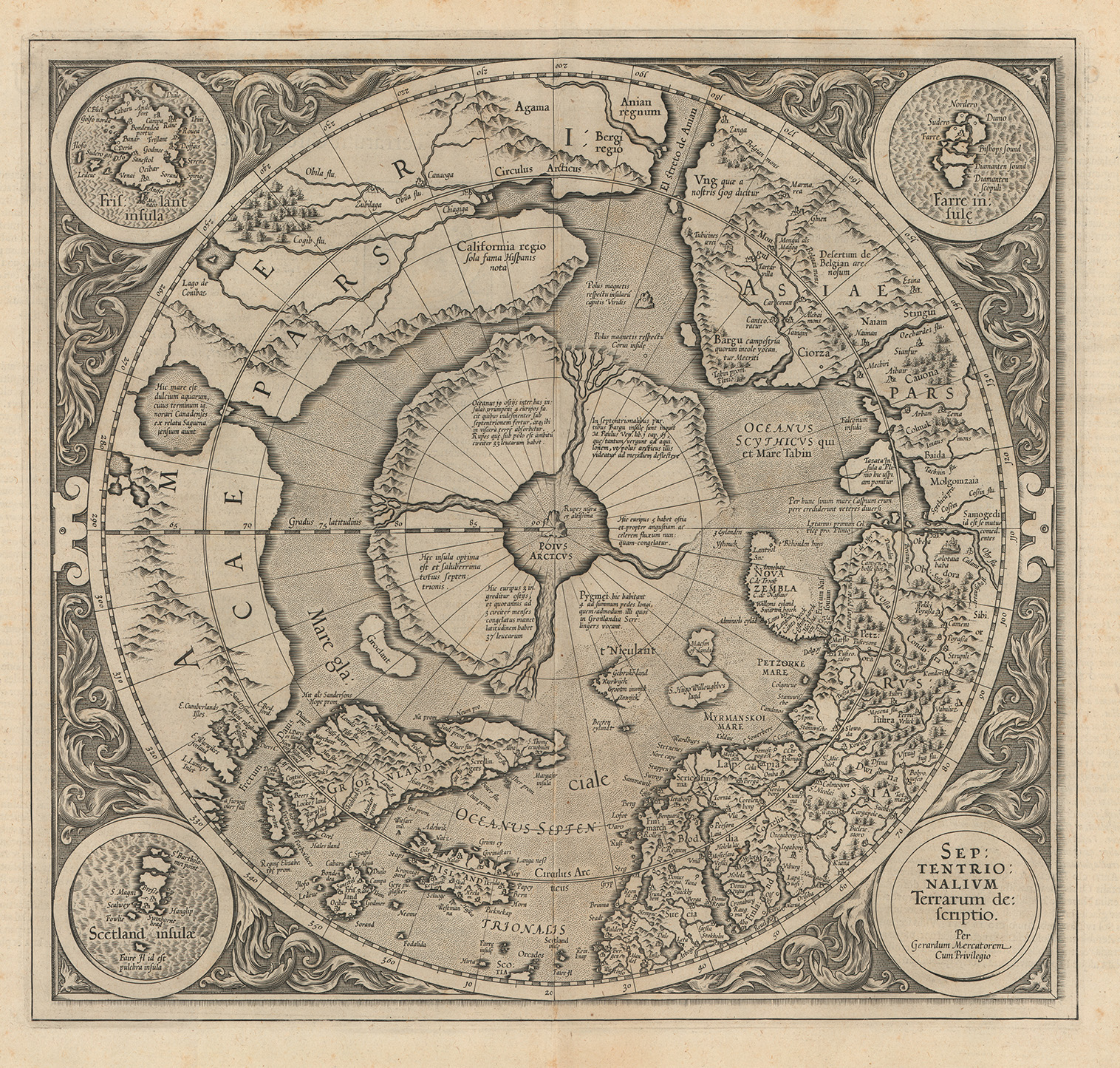
Gerard Mercator’s iconic Septentrionalium Terrarum descriptio (or roughly "Northern Part of the World Described"), the first printed map focused on the North Pole, first published in Duisburg in 1595, is represented now in UTA’s collection by a fine uncolored second state printing published in Amsterdam by Henricus Hondius in 1630.1 In the very center of the map is a mythical rock (the Arctic Pole or Polus Arcticus, labeled as “rupes nigra et altissima” ("high, black cliffs") and lying in water or ice. This is almost entirely surrounded by lands that are separated by four flowing rivers or channels leading from seas that are located north of the three continents of North America (at left), Europe (at lower right), and Asia (at upper right). The islands of Greenland, Iceland, and Frisland (mythical) appear at lower left. Beautifully engraved floral and strapwork ornaments and roundels picturing Frisland, Scotland, the Faeroe Islands, and the map’s title frame the hemispheric map itself. Particularly interesting are the wishful representations of a Northwest Passage, California as recorded only by the Spanish, and the Strait of Anian between America and Asia. Mercator, best known for his famous projection and a 1569 world map, died in 1594, a year before the publication of this map in an atlas issued by his son Rumold. In 1604 the Mercator family sold the atlas’ copperplates to Jodocus Hondius who reworked them and published this map in Amsterdam in the second state seen here in their atlases from 1606 to 1639. The major differences between the two states are that the first state shows complete borders around the island of Nova Zembla off the Russian coast as well as around the land in the lower right center of the map whereas Hondius’ second state omits them.2
As the results of new European explorations in the Arctic began to circulate, in 1636 Hendrik Hondius began replacing the old Mercator polar map in the Mercator-Hondius atlases with a second one. Titled Poli Arctici, et Circumiacentium Terrarum Descriptio Novissima roughly translated as “Arctic Pole, and Adjoining Lands Newly Described,” this map is also represented in the Greenhouse-Lazar donation:
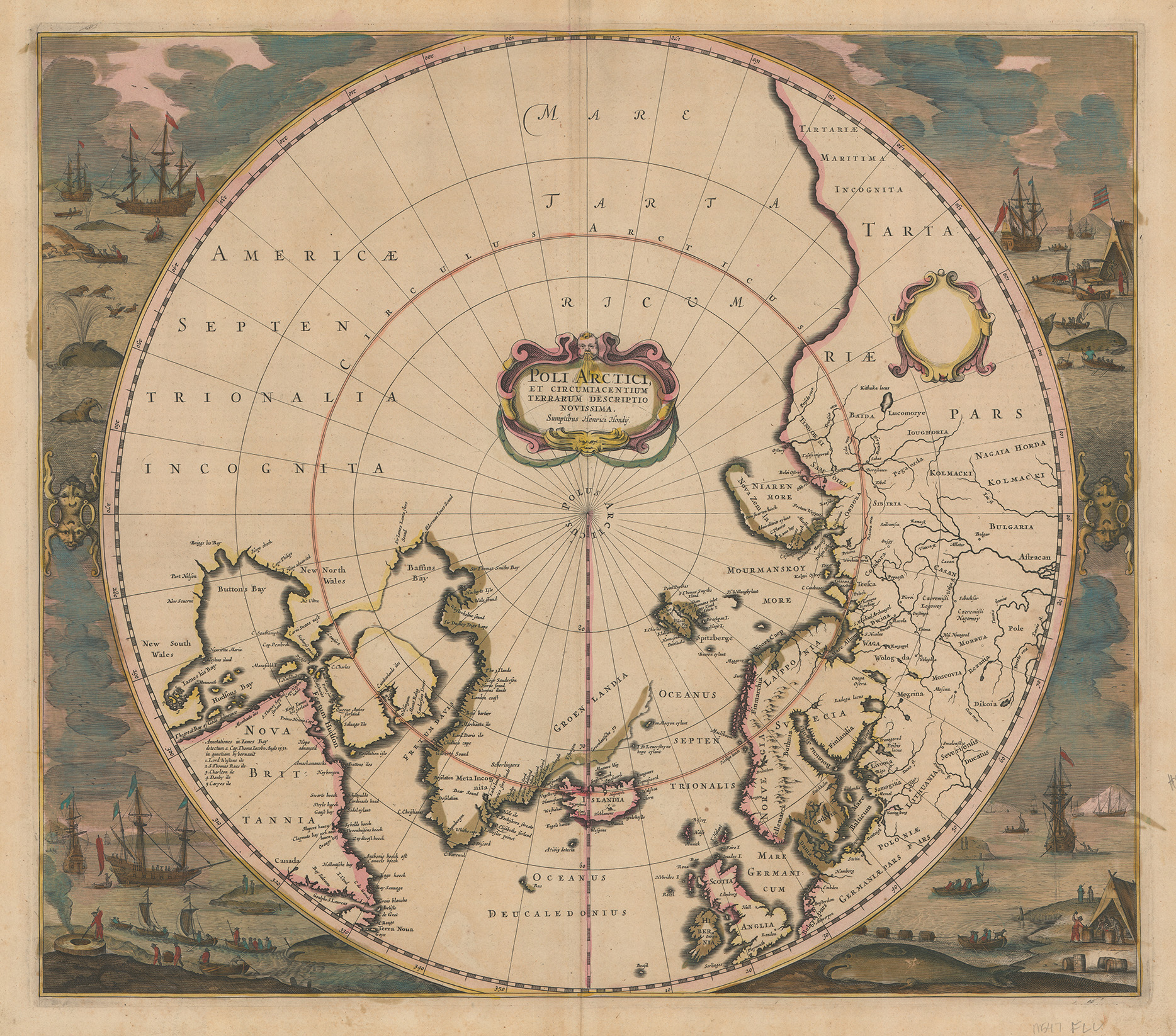
Beautifully hand colored, it was pulled from an early state of the copperplate and has fascinating Dutch whaling and walrus-hunting scenes surrounding the map as well as Latin text on the back. It could have come from any one of three editions of Hondius’ Atlas Novus, published in Amsterdam in 1638, 1641 or 1644. Hondius eliminated much of the speculative cartography of Mercator’s map by substituting better coastal outlines from more credible sources and by leaving large areas blank where no reliable information was available. For examples, Hondius relied heavily upon English mathematician Henry Brigg’s map of The North Part of America from 1625 which included information from the explorations of Martin Frobisher, Henry Hudson, George Weymouth, Thomas Button, William Baffin, and others. Bristol merchant Thomas James’ map also influenced Hondius.3 An immense area labeled simply “Americae Septentriontrionalia Incognita” or “Unknown North America” replaced the much-hoped-for Northwest Passage and the areas where Spanish thrusts northward on the Pacific coast of North America had been seen earlier on Mercator’s map. The mythical islands from the Mercator map surrounding the “Polus Arcticus” in the center of the map are completely gone. Of particular interest are the Dutch late Mannerist or early Baroque style grotesque ornaments appearing to support the hemisphere at middle left and middle right.
![Frederik de Wit, [Polus Antarcticus] Terra Australis Incognita, (1666). UTA](/sites/default/files/inline-images/20112653_med.jpg)
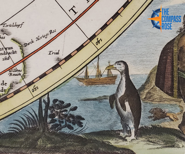
The Frederik de Wit and Jansson Heirs-issued Antarctic map completing the set is often referred to by its original title “Polus Antarcticus.” When first produced by Henricus Hondius in Amsterdam in 1639, this popular map had a cartouche with this title in the lower left of the hemisphere and a blank cartouche in the middle left. Since the words “Terra Australis Incognita” appear in the center of the untitled later editions (and in the earlier ones too), these words are often used as a secondary title. The map was re-engraved several times and appeared in many Dutch atlases by the Hondius and Jansson families and others as late as the 1680s. The map donated is a re-engraved version by Frederik de Wit with excellent hand coloring. It possibly came from Atlas contractus, sive Atlantis majoris compendium..., published in Amsterdam by the Jansson Heirs in 1666.4 When updated, Hondius' cartouches were omitted and new map details substituted. As early as 1650 Johannes Jansson added the 1642 discoveries of Dutch explorer Abel Tasman (part of New Zeeland and the island of Tasmania) to the bottom center of the composition and added the name “Nova Hollandia” to the land that eventually became known as Australia.5 The southern tips of South America and Africa, the partial outline of the west coast of Australia, and the pictorial compositions in the corners were on Hondius’ original version of the map. Hondius undoubtedly intended the scenes to represent indigenous inhabitants of the southern regions, including South Africans, South Americans, South Sea islanders, and possibly Aboriginal Australians. Interesting details in these scenes include a penguin at lower right and what appears to be a swimming African lion with an unusual tail --apparently a Dutch illustrator’s interpretation of a text describing sea lions! There are more of these "sea lions" at the extreme lower right along with a figure clubbing a giant penguin. In the scene at upper right, a native woman has her back to the viewer to reveal her long, neatly-braided hair. In the background are a square-rigged East Indiaman as well as a lateen-rigged vessel of non-European origin.
1 Philip D. Burden, The Mapping of North America I: A List of Printed Maps (Rickmansworth, Herts, England, U.K.: Raleigh Publications, 1996), pp. 113-114, no. 88.
2 Burden, pp. 113-114, no. 88; Barry Lawrence Ruderman Antique maps, stock no. 62290, https://www.raremaps.com/gallery/detail/62290/septentrionalium-terrarum-descriptio-mercator, accessed 6/12/2020.
3 Burden, Mapping of North America (1996), pp. 265-166, 298, 311-313, no. 246.
4 See Wit, Frederik de., and Jansson heirs."[Polus Antarcticus]." Map.1666. Norman B. Leventhal Map & Education Center, https://collections.leventhalmap.org/search/commonwealth:7h14b183m (accessed June 12, 2020).
5 Robert Clancy, The Mapping of Terra Australis (Macquarie Park, NSW, Australia: Universal Press Pty Ltd., 1995), pp. 80, 126.
Add new comment