
by Ben Huseman
by Ben Huseman
The purpose of The Compass Rose is to raise awareness of Special Collections' resources and to foster the use of these resources. The blog series also reports significant new programs, initiatives, and acquisitions of Special Collections.
This is the final of a series of three blogs describing the recent donation of fourteen rare antique maps by Lee R. Greenhouse and Flora E. Lazar to The University of Texas at Arlington Libraries Special Collections. In Part One we featured five early maps of Asia and in Part Two three early polar projections. This final blog describes the last six maps in the group. While eclectic in subject matter, the maps all add something new to UTA's growing cartographic collections.
The Greenhouse-Lazar donation includes three early items relating to the Mediterranean world. A fine uncolored engraving of the city of Algier[s] probably dates from 1657 when it was originally included in one volume of Dutch mapmaker and publisher Joannes Janssonius’ so-called “Town Books,” modeled upon Braun & Hogenberg’s extensive late 16th-century compilation of city views of the world titled Civitates Orbis Terrarum:
![Janssonius, Algier[s]](/sites/default/files/inline-images/20112651A_med.jpg)
Janssonius’ version is in fact quite similar to Braun & Hogenberg’s view, which in turn derived from an engraving by Antonio de Salamanca.1 It is significant to note that reliable up-to-date eyewitness views of Muslim-ruled cities were apparently hard to obtain in western Europe. The outdated view, depicting extensive fortifications and slave-powered war galleys, probably ultimately stems from a sketch presumably made during the unsuccessful Spanish siege personally led by Holy Roman Emperor Charles V on the Muslim-ruled city over a century earlier, in 1541.2
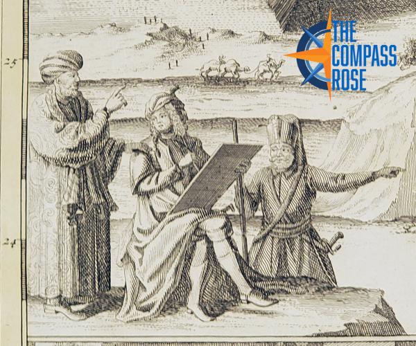
Johann Baptist Homann and son Johann Christoph Homann's map titled Aegyptus Hodierna / Das Heutige Aegypten [Egypt Today] was published in Nuremberg around 1720:

The Homanns, founders of what for many years was the most important cartographic publishing house in the German-speaking world, compiled the map based upon information from Paul Lucas (1664-1737), a French traveler, merchant, naturalist, physician, and antiquarian working for King Louis XIV. Lucas made three trips to Egypt and the countries of the eastern Mediterranean between 1699 and 1717. He traveled up the Nile River as far as the cataracts, and for years his report about the Upper Nile was the best information about the area available in Europe.3 The Homanns' map shows the Nile in detail from the Mediterranean as far as the cataracts. The seated figure with a drawing tablet at far left probably represents Lucas, wearing local garments over his stylish early 18th-century European stockings and periwig. He is flanked by a local guide and translator.4 The keyed vignettes surrounding the figures at left picture, beginning from the top: A. the cataracts; B. the pyramids, the river, and the city of Memphis; C. antique pottery; E. an ingenious incubator for hatching chicks that Lucas saw north of Cairo and thought worth reporting; and D. subterranean crypts holding mummies.
The lengthy Dutch title of the next map, engraver Daniel Stoopendaal’s map of the Holy Land, translates roughly as "Wanderings or Forty-years Travels of the Children of Israel from Egypt, across the Red Sea, in the Wilderness, into the Promised Land of Canaan....”

It was apparently published in Dordrecht or Rotterdam by Pieter and Jacob Keur, possibly between 1700 and 1730.5 However, other maps by Stoopendaal and the Keur family appeared in Dutch Bibles and theological works as early as the 1680s.6 This map includes Palestine and northeastern Egypt with pictorial and textual references to Biblical scripture throughout. For examples, the larger illustrations at the bottom depict, from left: the Hebrew leader and prophet Moses striking a rock with water gushing forth, providing drink to the children of Israel who have been wandering in the desert (Numbers 20:11); Moses receiving the Ten Commandments on Mount Sinai (Exodus 20); the children of Israel, having been bitten by venomous snakes, coming to Moses and the prophet Aaron, who erect the image of a brazen serpent on a pole, so that anyone bitten may look upon it and live (Numbers 21: 4-9).
The last three items from the generous donation are all British, and, being in English perhaps require less description here. There is Thomas Kitchin's map of Asia for William Guthrie’s New Geographical, Historical and Commercial Grammar, published in London in about 1783:

UTA Libraries Special Collections already has a Guthrie’s geography (not yet scanned) donated years ago by Mr. Murray Hudson of Halls, Tennessee. It contains this map, but a separate map allows greater ease of access and more exhibit opportunities.
Finally, the Greenhouse-Lazar Map Donation includes two maps by John Arrowsmith, both dated 1840:


Special Collections also has variants of the maps of Russia & Poland and Burmah, Siam, and Cochin China (southeast Asia) in an Arrowsmith London Atlas from a later date (not yet scanned). Nonetheless, each map is different, contains surprises for the persistent viewer, and provides a useful window into a world long past. For the most obvious examples, states like Poland, Ukraine, Belarus, Romania, Latvia, Lithuania, Georgia, Azerbaijan were either in the sphere of Imperial Russia at the time of the maps or did not exist under their present names. And such names as “Burmah”, “Siam”, and “Cochin China” have long disappeared from modern maps of southeast Asia, being replaced by Myanmar, Thailand, Vietnam, Laos, and Cambodia.
The maps in the Lee R. Greenhouse and Flora E. Lazar donation will allow UTA Libraries’ Special Collections to present a fuller and more balanced picture of the history of cartography. The eclectic varieties of maps in the donation will also help us better relate to the wide variety of University interests as well as the interests of local and international visitors who normally walk through our doors. If visitors find these maps interesting, they just might find our local and regional maps as well as other collections equally intriguing! And they are also, of course, now available to everyone on the internet.
1 R. A. Skelton, intro., Braun & Hogenberg, Civitates Orbis Terrarum ‘The Towns of the World’ (3 vols.; Cleveland and New York: The World Publishing Company, 1966), vol. 1, p. XLII.
2 Interestingly, Charles V’s siege of Algiers was a disaster for the Spanish despite his large force and the presence of many of his most illustrious military commanders, including Hernan Cortes, recently returned from Mexico.
3 Alfred Lacaze, “Lucas (Paul), voyageur et antiquaire française,” in Nouvelle Biographe Générale, ed. by Ferdinand Hoefer (Paris: Firmin Didot Frères, 1852-66), XXXII, cols 122-25.
4 The Homanns included on their map of the territory drained by the Mississippi a portrait of the French explorer Father Louis Hennepin and scenes drawn from illustrations in his published account. Therefore, it is quite possible that the Homanns used illustrations from an edition of Lucas' published travel accounts to embellish their Nile map. Further research could confirm this. Interestingly, Lucas reportedly did not credit his translator and guide Hanna Diyab (1688-after 1763), a Syrian Maronite writer and story teller who accompanied Lucas on several of his travels, including Egypt. Even more interesting, some scholars credit Hanna Diyab as the source of the tales of Aladdin and Ali Baba and the Forty Thieves in the One Thousand and One Nights translated by Antoine Galland. See John-Paul Ghobrial, review of Hanna Diyab, D’Alep à Paris: Les pérégrinations d’un jeune Syrien au temps de Louis XIV, ed. and tr. Paule Fahmé-Thiéry, Bernard Heyberger and Jérôme Lentin (Paris: Sinbad, 2015), The English Historical Review 132:554 (February 2017): 147-149.
5 Ronald Vere Tooley, Tooley’s Dictionary of Mapmakers. Rev. ed. by Josephine French, Valerie Scott, Mary Alice Lowenthal (4 vols.; Tring, Hertfordshire, England: Map Collector Publications in association with Richard Arkway, Inc., 1999-2004), vol. 3, p. 22.
6 Tooley, vol. 4, p. 221.
Add new comment