
by Isaac Williams
by Isaac Williams
Lack of public transit options are a problem in the Dallas-Forth Worth Metroplex. If a UTA student wanted to commute to campus from Dallas without using their car, their options include riding the Trinity Railway Express and then either carpooling, ridesharing, or biking to campus from the TRE station in Arlington. There is no bus or shuttle that currently transports TRE riders throughout Arlington, or even to UTA.
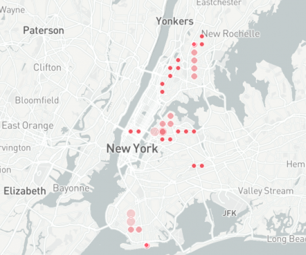
This is one example of a problem that exists throughout the country: transit deserts. While New York City’s subway system is famous, New Yorkers living in the outer boroughs of the city also face this problem. While it might be simple to catch a train from Manhattan, it is much less so in places like Queens or Staten Island. Residents of outer boroughs often need to use more than one mode of transit to reach their destination. Instead of walking to and from the train station, they must also take a bus, bike, rideshare, or ferry before even reaching the train. This means that jobs, groceries, education, childcare, and errands are more out of reach for people who do not have easy access to transit.
Because I once had a six hour round trip bus commute to my job in Los Angeles, I was curious about what the Metropolitan Transit Authority was doing to solve this problem in NYC. I used data from Open Data NYC to create a map showing the growth of the NYC subway system from the early days of the Long Island Rail Road (LIRR) until 2018.
Some stations were closed and then reopened--such as the Cortlandt Street station, which reopened in 2018 after being closed in the wake of 9/11. Some stations originally serviced the Long Island Rail Road (LIRR), and are featured in this map based on the date their physical structures opened, and not when they became associated with the MTA. Finally, I manually added the opening dates of each station via information from Wikipedia.
This map is only one way of viewing transit deserts, but it shows that as of 2018, the MTA has not opened subway stations in the parts of New York that are least connected. It also shows a burst of activity in the first half of the 20th century, followed by relatively small amounts of development in the more recent future, which is mostly concentrated in Manhattan, Brooklyn, and some parts of Queens.
Next steps:
Add new comment